| |
|
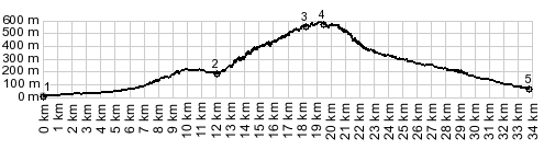
1.(10m,00.0km) START-END
WEST: Capezzano Pianore: jctSR439 - Via Italica
2.(174m,12.0km) profile turns left onto small road from
SP1
3.(547m,18.3km) turnoff to right goes to various small
villages and the valley
4.(580m,20.0km) TOP: point slightly before Passo Del
Lucese; pass elevation is 558m
5.(80m,33.8km) START-END WEST: SP32 terminates onto SP2,
south of Borgo a Mozzano