| |
| |
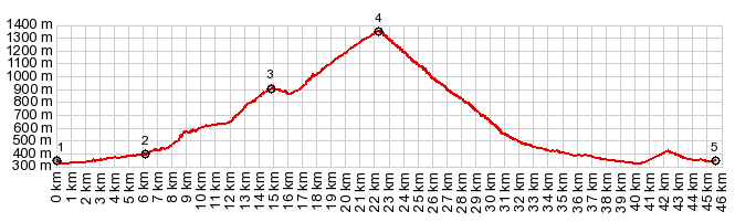
Col De Labays This pass is great for cyclists
who like climbing for climbing's sake. There is
barely a far view to distract from agonizing
about the steepness data, displayed along the
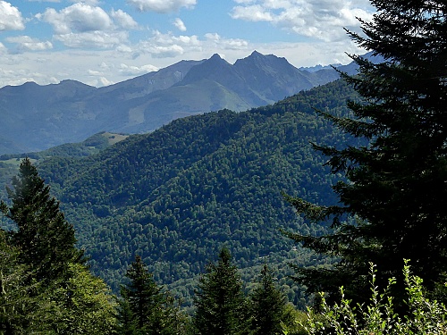
road. People who like to follow green tunnels
along streams also get their due share. The
canyon on the lower east side is as cool and
peaceful as you can get with pavement.
Actually I think my favorite part of
this climb is the beginning - where the road
bounces around a stream through roller coaster
tunnel of green vegetation. Unfortunately I didn't
take any pictures there. These first few kms are
considered easy by the informational tablet,
because of the "average grade". I suggest you form
your own opinion.
From North. The
other aproach to Col de Labays is on D132, which
is wide main road, serving a ski area, but not
with much traffic at least in the summer. It also
serves as approach to Col de Soudet and Col
Pierre-St-Martin. Both of these are higher.
But the profile does turns down at this point. Also, all the interesing scenery is
really further up towards these two higher
summits. Going down is a fast ride where the trees
take over after about a km. Ramps and switchbacks
and long valley descends eventually lead to Arete,
and onwards to Oloron.
A Dayride with this point as
shoulder summit is on page Col Pierre St
Martin |
 Eventually the green tunnel leaves
the stream, then after the first intense
switchback workout meets up with the road from
Eventually the green tunnel leaves
the stream, then after the first intense
switchback workout meets up with the road from |
|
advertisement |
|
|
advertisement |