Col D'Ichere s(u)
There are two low passes
connecting the valley of the La Gave
d'Aspe and the valley of the Cours du Gave
D'Issaux. This is the lower of the two,
but actually the more scenic in my
opinion.
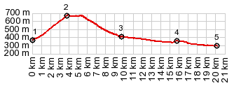 |
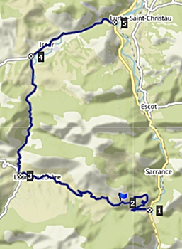
1.START-END SOUTH:jct
N134-D241,north of Bedous
2.TOP:Col d'Ichere -674m
3.bridge over La Gave d'Issaux, at
jct with route to Col de Llabays
4.jct with D918, before reaching
Issor
5.START-END NORTH:jct D918 - N134 in
valley of La Gave d'Aspe
|
 Approaches Approaches
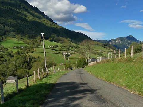
From West. What
looks like a turnoff from N134, quickly
funnels into a narrow green funnel of a
road. But as it approaches its upper
regions, the trees open up, and the road
looks out over a pastoral scene with vines
on old farm buildings and apparently happy
cows and oxen careening through the verdant
pastures. The road reaches a point, higher
than the officialy signed summit, before
getting there, which wreaks havock on the
"every km" elevation data signs, which are
not prepared for such an eventuality. But
the difference in elevation is really
negligible, though this does not lessen the
confusion caused by the signs.
From
South. A fast curvy decent leads into
the village Idios, comprised of farm houses,
tied together by green vines (in many
locations). From here you can decend on
mostly imperceptible grades towards Oloron.
You also have the choice of an impossibly
steep pastoral climb to Col de Labays
or also Col de Liens
|
|
|
cLiCk on image ,
arrows , or thumbnails to advance
slideshow
|
|
 A Dayride with
this point as intermediate summit is on
page:
A Dayride with
this point as intermediate summit is on
page: