| |
| |
E65/D8 Senj - Stinicia s(u) I rode this little summit when this was still Yugoslavia, and I was convinced, that this was the most beautiful coastal road I could ever have dreamed of riding. In the last decades, I have met several cyclists who come to a different conclusion. They find this road hard to enjoy because of the traffic. I rode this again as a
dayride on a Sunday in mid October 2021,
and the traffic was not bad. It was not as
good as during communist times, but what
do you expect ? The scenery is still as
stunning as I remember it.
This is the scenic side of the
climb, morning light is best, and it's all
about three small rocky islands between the
major islands Rab and Krk. Each one seems to
have its own brand of dry perched rocky
gleam, complementing the blue sea. There is
a private resort near the bottom, before the
first of many false summits. It may look
interesting to explore - it is not. The next
knoll next to the road beckons to be
walked up. It is thorny and the limestone
cuts through shoes that may not have been
made for this terrain. It is still far from
the highest point. When the summit comes
closer it will be obvious.
From
South. (described downwards) As the
road rounds the summit, the dessert island
scenes disappear. Rab has a different
appearance on this side, and the later light
makes it a flat paper cutout. The profile
goes down to the ferry towards Rab. The
coastal road stays higher.
Dayride with this point
as highest summit:
( < jct 5047-5048 Veprinac s(u) | 5110 Smokvica-Senj(sh) > ) E65 Senj - Stinica s(u) x2: ~4km north of Senj <> Senj with sightseeing detours <> D8 south <> Svet Juraj with sightseeing detours <> E65 Senj - Stinica s(u) <> turnaround point ~420ft below summit: 54.5miles with 3860ft of climbing in 5:18hrs (garmin etex30 r5:21.10.17) A Day on a Tour with this point as highest summit: E65 Senj - Stinica s(u): Senj > Prizna > ferry to Pag[island] > Pag[town]: 59miles (mechanical odom m1:89.11.13) Notes: part of a tour from Bremen to Istanbul |

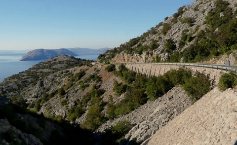 There is actually
a small shoulder next to the road going
south, but not north. Remnants of an old
narrow road predecessor, complete with
hand-built supporting walls and stone arch
bridges can be seen in places, next to the
new highway. What a bike road that would
make in a country that can afford these
things !!!!
There is actually
a small shoulder next to the road going
south, but not north. Remnants of an old
narrow road predecessor, complete with
hand-built supporting walls and stone arch
bridges can be seen in places, next to the
new highway. What a bike road that would
make in a country that can afford these
things !!!!|
|
advertisement |
|
|
advertisement |