| |
| |
5110 Smokvica - Senj(sh) This traverse above the sea
is one of several that can all be strung
together between Senj and Rijeka. But I
have only tried this particular
combination. It is in a kind of "golden
zone" for cycling along the coast. It is
far away from the traffic of the
magistrale coast road. The few vehicles I
saw up here were all Croatian, and I
didn't see the slightest hint of another
bicycle. Not only is it far away from
coastal traffic, it is also above, so the
views are even better. But it runs below
the crest of the Velebit Mountains, which
are mostly a deep dark forest on a rolling
plateau, with nary a view to be found in
any direction. There are plenty of open
spots along this road that shed various
shades of great light onto the sea and its
islands.
A wide traverse along the hill
leads to ever improving views onto the
escarmpent of Krk. Finally the road turns
into a first shallow ravine between folds of
these flowing hills. A collection of houses
shelters here. The road keeps on climbing in
traverses, until a second escarpment of Krk
becomes visible. Near what looks like it
might be a top, mysterious signs point to
"Terrestrial Mazes" and "Glass Chapel",
signed in English and Croation. The map also
shows a road slightly to the west, which
would be useful to continue the traverse
towards the north. I missed it. But this is not the top. It
comes later along the traverse south. The
road stays in bushy to forested terrain. From
South. (described downwards) A
turnoff :marked "Drezenica" leads on a
narrow paved road towards that town.It is
not marked on any of the maps I have. But
continuing on the 5110 traverse of the
profile, the best parts are still ahead. The
road becomes a windmill boulevard, the
modern turbine kind. From their exposed
bases a great view of the sea and islands
below is to be had. The profile takes the
second signed road down to Senj. The one
before that is at least at the start not
paved. But the one shown on the profile is
an excellent road all the way down. Much of
it runs on exposed grassland with trees
pruned by the wind into letter shapes - most
likely the best part of the ride. Sidetrip to Terrestrial
Mazes and Glass Chapel This narrow paved path leads
to a picturesque hill above the sea, adorned
with mazes and inspiring sayings, as well as
totally natural exposed limestone clusters
that make the perfect foreground for the Krk
coast. A little further along this paved
path is a picturesque chapel and fountain.
It is the kind of magic spot that is a
thrill to come across unexpectedly without
another soul of any kind around, before
encountering the souls that have been there
forever.
Dayride with this point
as highest summit:
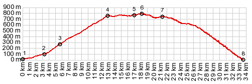
( < E65 Senj - Stinica s(u) | jct 5110 - 59132 Krivi Put s(u) > ) PARTIALLY PAVED / UNPAVED 5110 Smokvica-Senj(sh), additional out and back: 5110 Smokvica-Senj(sh) ~4km north of Senj > D8 north > Smokvica > 5110 east <> out and back to Terrestrial Mazes, Glass Chapel and end of road at powerline >> 5110 east <> out and back on paved forest road marked "Dreznica" << turnaround at less than 300ft below highpoint ~7miles after turnoff >> 5110 Smokvica-Senj(sh) > Senj > back to starting point ~4km north of Senj: 47.1miles with 5370ft of climbing in 5:29hrs (garmin etrex30 r5:21.10.19)  |
|
|
advertisement |
|
|
advertisement |