| |
|
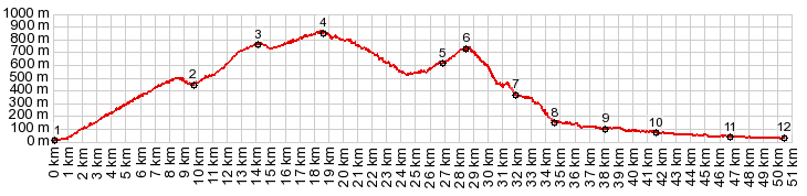
1-4: same points as on the Puerto Santopilar profile
05.(26.8km,600m)profile turns left, first turnoff to Comares
06.(28.5km,720m)TOP AFTER PUERTO SANTOPILAR: highest point in Comares
07.(31.8km,370m)unpaved route ends and joins paved route from Puerto Santopilar
08.(34.6km,150m)route turns right at this jct; left goes to Colemar
09.(38.1km,100m)Benamargosa
10.(41.6km,070m)Trana
11.(46.7km,040m)route goes through Trapiche on A7295
12.(50.4km,030m)START-END WEST: Velez Malaga
|