| |
| |
Col de Cochette
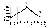
In a day of cycling over mountain
passes, there are some, that definitely are the
main meal of the day. In comparison others might
be designated as breakfast or dessert. This is one
of the the latter two. For me it was the first
pass of the day, before continuing on to Col du Grand
Cucheron. It that way is was a breakfast
pass. But the early morning light was so great,
especially compared during the deteriorating light
conditions of the afternoon, that it sticks in
memory more like a dessert.
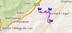
The road climbs over a narrow forested ridge, sandwiched between the Bauges Massif and the Hurtieres Mountains. Both the Hurtieres and the Montraillant could be described as foothill areas between the Bauges Massif and the Chaine de Belledonnes.
But then you would miss the views. From Villard
d'Hery serveral forested switchbacks climb on a
low traffic route. On the other side of the valley
the Dent d'Arclusaz steadily seems to grow in
size. The geological syncline structure in this
sheer wall of sedimentary rock layers is clearly
visible. This is a textbook example of the upper
rock layers being hardened by the compression in
the syncline. Consequently they are harder to
erode and this mountain tooth formed. Another
entire mouthful of giant dental like structures to
the west also make a great view - the last
glimpses of the Chartreuse area on this ride. The
route crests past a wood cross, and emerges from
the forest to reveal the first view of the
Belledonne Range. A mountain meadow with a bench
above to the north invites for a rest From East. The road is
narrower on this side. A quick descent leads to la
Trinite. The small collection of houses seems to
have a special talent for disguising new
renovations as medieval decay. Just a short
distance on the the straight main road to La
Rochette in the south, and one has the opportunity
to start climbing again to La Table and Col du Grand
Cucheron and/or Col de Champlaurent.
A dayride with this point as intermediate
summit is on page: Col de Grand
Cucheron
|
|
|
advertisement |
|
|
advertisement |