| |
| |
Collado de Algueda
This little dessert summit seemed
much higher to me than it actually is. Three
factors play into this. First, a short very steep
section made me work hard for the elevation.
Second, the far views on the south side give the
impression of a high vantage point. Third, the
starting elevation is only 30 meters. And still -
this is not a coastal summit. And besides, ...
this was just an all around perfect day weather
wise and picture wise.
The best view is actually behind. The subject is
the Sierra Orihuela (not the Sierra de Albatera as
the first caption reads). This little range does
not show up on many maps, but instead on countless
photographs. I include two pictures of this view,
that I found on the web. The first one is possibly
a km off the profiled route (according to the
panoramio map), and the last picture looks like
one that I took on the approach to the pass. The
only difference is, that I included a large grove
of yucca cacti (or lookalikes) as foreground. Also
- this was a perfectly clear day without the
slightest hint of haze - perfect conditions for a
dessert photo biking day. 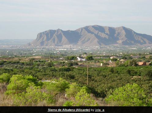 Approaching the top the road becomes very steep
for a short time and winds around an adventurous
road cut to reach the top. Along the way are a few
picturesque abondoned houses, that never seem to
get photographed, well on their way to "staccato
monuments to decay". The top changes the viewshed
to a more gentle landscape of low dessert ridges
to the north.
|
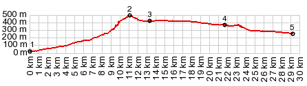
 From North. An extremely
short roll leads down to Hondon de los Frailes, a
small vacation town with a laid back atmosphere
and street restaurants, where people come on
weekends to enjoy a slightly cooler mountain air
and a main street free of cars. At this point the
profile turns right and descends back into a
valley on a less scenic road with more traffic.
But it stays north of the line created by the
Serra Crevillant. The slope here is much gentler.
From North. An extremely
short roll leads down to Hondon de los Frailes, a
small vacation town with a laid back atmosphere
and street restaurants, where people come on
weekends to enjoy a slightly cooler mountain air
and a main street free of cars. At this point the
profile turns right and descends back into a
valley on a less scenic road with more traffic.
But it stays north of the line created by the
Serra Crevillant. The slope here is much gentler.|
|
advertisement |
|
|
advertisement |