| |
| |
Castillo de Loarre s(u)/(ow) The next best thing to a road over
the mountains is a road along the mountains (I
think). Sometimes it is even better, like when a
storm is in the mountains but it is friendly,
sunny and windy on the downslope side. This is
such a road along the mountains. A one-way
summit climbs up to an impressive and
touristically important castle and delivers far
sweeping views onto the receding foothills of
the Pyrenees until they disappear completely and
dissolve into a plain.
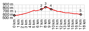
From East. Actually
this is the road you are most likely to go up,
when you follow the signs for the castle. The
highest point of the two way summit is the
junction with the other approach, really the only
paved turnoff from the climb (at least that I can
remember)
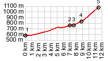
Out and Back to Castillo de
Loarre one-way summit
At the summit are many possibilities
for mountain or gravel bikers, including going
down to the village Aines
Dayride with this point as
highest summit:
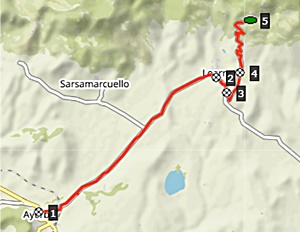
COMPLETELY PAVED ( < Alto de Zuriza | Puerto Sierra Major > ) Castillo de Laorre s(u) : a short distance east of Ayerbe > A1206 east <> out and back to Sarsamacuello <> separate out and back to Linas Sarsamacuello >> A1206 east > Castillo de Laorre s(u) via main road <> out and back Castillo de Laorre(ow) >> Laorre > A1206 east > Bolea > Pulibulea << turnaround point in Linea > A1206 west > Aines > back A1206 via different access road > A1206west back to starting point east of Ayerbe: 48.7miles with 4800ft of climbing in 5:32hrs (garmin etrex30 r5:22.09.25) Notes: quite a bit of time spent walking around Castillo de Loarre, Bolea and Pulibulea 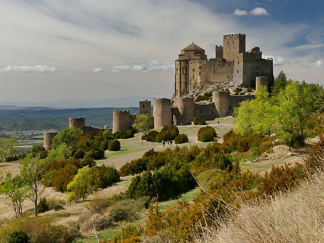 |
 This
climb is signed for cyclists with upcoming average
grade data each km. But you might miss a few
because of distraction by amazing views of the
village below, grouped around the church tower, or
the castle above with an unusual solitary tower
inside the mighty castle walls. This is quite a
steep climb with several switchbacks, and tourist
traffic on the weekends can be considerable. But
drivers seem to be very cycle friendly and like to
cheer them on.
This
climb is signed for cyclists with upcoming average
grade data each km. But you might miss a few
because of distraction by amazing views of the
village below, grouped around the church tower, or
the castle above with an unusual solitary tower
inside the mighty castle walls. This is quite a
steep climb with several switchbacks, and tourist
traffic on the weekends can be considerable. But
drivers seem to be very cycle friendly and like to
cheer them on.|
|
advertisement |
|
|
advertisement |