| |
|
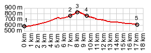
1.START-END WEST:Ayerbe
2.profile turns left into village Loarre
3.TOP: shortly before reaching access road to castillo, 830m
4.profile rejoins A1206
5.low point, immediately before reaching Bolea
|

1.START-END WEST:Ayerbe
2.turnoff to village Loarre, profile continues
straight
3.profile turns left on Castillo access road
4.alternate route through Loarre joins from left
5.TOP:parking lot before castillo, 1080m
|