| |
| |
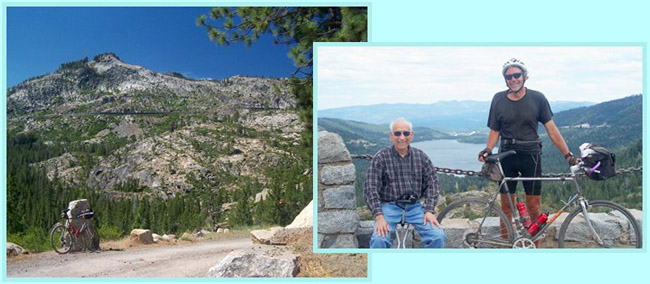
Donner Pass
The summit section of Donner
Pass is one of the few roads, that really seem
like they are tailor made to be bicycled. One
prerequisite for this is almost always, that
there is a quicker way to bypass the route for
cars. There is in this case : US80 crosses this
mountain divide to the north. I saw almost as
many bicycles as cars on this road. The section
that causes people to stop and look around is
really pretty short, but it is beautiful, and
history lives on this pass.
Approaches From West. The description starts at exit
165 of I80. Here starts the section labeled as
"US40 scenic bypass". It makes a great bike ride,
but you can't make a day loop out of it. The label
"historic bypass" would fit even better than
"scenic bypass". Because every few miles there is
another excuse - even valid reasons - to get off
the bike and read another historical information
tablet next to the road. The first one comes soon after the exit. An old
stone ruin was once was a souvenir shop next to
the old "Lincoln Highway Route". Now US40 makes
its way through the trees and houses hidden in the
forest, crosses under I80, and at the next turnoff
you can actually see part of the original old
roadbed of US40. It was the first transcontinental
auto highway. The embankments holding it next to
the river look more like something my grandfather
constructed in his garden, than a highway
nowadays. Only a mile or two can still be driven,
and these days even cycled. 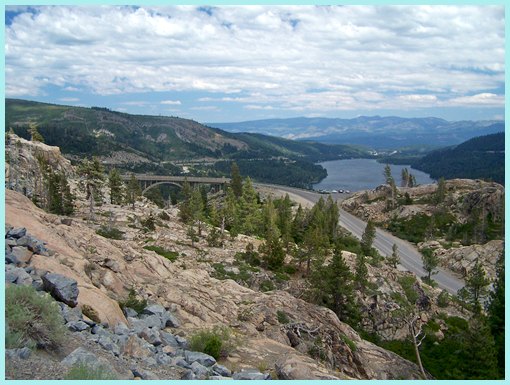 Now the road crosses the Yuba River and the first
mellow climb runs along a set of adventurous
houses, set amongst boulders on the river. These
boulders are just about as big as he houses
themselves. US40 continues within ear shot of
US80, climbing only slightly. Even when the
information tablets next to the road talk about
nothing else except, the ski industry, Sugar Bowl,
the ski town of Norden, ski lodgments and so on,
the road continues in topography that does not
look very challenging for a skier. Yes - there are
mountains on both sides, but they do not look big
from this vantage point. The railroad manages to
climb up the valley also. The summit comes up
quickly without need for any curves in the road.
The top is a busy place with a large building
belonging to a ski school, transmission towers on
one side, the Pacific Crest Trail crossing and
another stretch of old historic US40, paralleling
today's US40 route. From East. (also described upwards) One
could make the argument that this approach really
starts in Carson City and follows the Truckee
River to the town of Truckee. But that profile
contains a long section with plenty of rolling
hills between Boca and Truckee, and I80 below Boca
is probably not the best bike route.
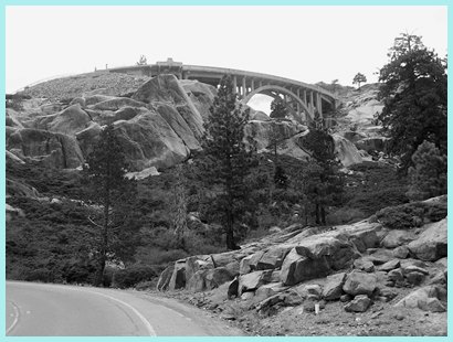
Okay - finally - there is some climbing to be
done after all. After a short time the road
reaches treeline. This short, last section to the
summit contains all the scenic thrills of the
ride. Above, the small, but adventurously placed
"rainbow bridge" swings the road to the top.
Across to the east the railroad is condemned to
run inside a stove pipe like show shed, that makes
sure that California Zephyr tourists are
frustrated by only catching second long glimpses
of the mountains. Several switchbacks of the road
maneuver between huge boulders of exfoliated
granite. Compared with these bicycles and cars
have something in comon. Both look like aunts. The
road reaches the top before you know it.
Dayride with this point as highest summit: COMPLETELY PAVED: ( < Sardine
Lookout s(u) | Brockway
Summit > )
|
||||||||||||||||||||||||||||||||
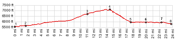
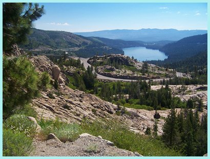
 So the profile starts on Ca267 at
a low point where it crosses Truckee River. A
shallow climb follows Ca267 into the town of
Truckee. Next comes a flat promenade along Lake
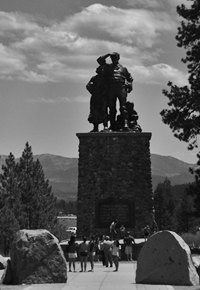
Donner. The beginning of this section is marked by
a bombastic statue of the Donner emigrants near
the entrance to Donner Lake State Park (picture on
right). Contining on US40, well marked bike lanes
on both sides separate a peaceful idyllic lake on
one side from a parade of extravagant lake front
homes on the other. An even nicer alternative for
this sections is riding around the others side of
the lake, starting in the state park. A short
stretch of forest road, closed to cars, connects
with the lake front drive on the west side.
Housing on the north side of the lake is not quite
as splashy.
So the profile starts on Ca267 at
a low point where it crosses Truckee River. A
shallow climb follows Ca267 into the town of
Truckee. Next comes a flat promenade along Lake
Donner. The beginning of this section is marked by
a bombastic statue of the Donner emigrants near
the entrance to Donner Lake State Park (picture on
right). Contining on US40, well marked bike lanes
on both sides separate a peaceful idyllic lake on
one side from a parade of extravagant lake front
homes on the other. An even nicer alternative for
this sections is riding around the others side of
the lake, starting in the state park. A short
stretch of forest road, closed to cars, connects
with the lake front drive on the west side.
Housing on the north side of the lake is not quite
as splashy.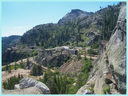
|
|
advertisement |
|
|
advertisement |