| |
|
|
|
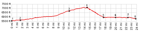
1.(5570ft,mile00.0)START-END WEST: I80 exit to Eagle Lakes Rd
2.(5670ft,mile01.5)profile exits I80 onto service road
3.(6740ft,mile11.1)START-END WEST ALTERNATE: Soda Springs
4.(7135ft,mile14.6)TOP: Donner Pass
5.(5980ft,mile17.5)jct with western access to South Shore Drive around Donner Lake on right
6.(5970ft,mile20.9)jct with eastern access to South Shore Drive around Donner Lake on right
7.(5910ft,mile22.3)START-END EAST: downtown Truckee
8.(5810ft,mile23.8)START-END EAST ALTERNATE: Brockway Rd crosses Truckee River
| |
![]()