| |
| |
This is what Arizona roads are best at, long climbs up slanted plains. But sometimes it's difficult to find a way down the other side of the slanted plain. Not so in this case. The other side of this rim climb is a spectacular canyon, that is more pronounced than the slanted plain climb from Globe. This is a major traffic thoroughfare, and there are rumble strips. But the climbing shoulders are so wide, it is actually a pretty good ride traffic-wise too, in my opinion, after you get used to the noise. Also, traffic in my case may have been extra heavy because it was 2 days before Christmas, but at least it was cool enough. As for the next climb to the
north out of the canyon, very spectacular -
But in that case it really is very difficult
to impossible to find a way back down on the
other side within a reasonable distance. There
is no other side. But if it's a one way climb,
where is the top? Due to these imponderably
difficult questions, a page for that climb
eludes me sofar.
From North.
(described downwards) Just looking at the
surroundings, it is actually completely unclear
if this is indeed the summit. All that is clear
is that the dessert is over, and that we are
surrounded by a juniper type forest, that is
pretty flat, though probably on a large scale
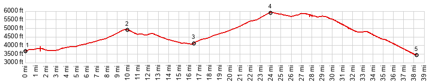
slant. The profile verifies that the next
little climb on this straight road over a high
plateau actually does not amount to much, and
the real summit was back at the rim. But the best part is just ahead.
What is just a forested hill at the entrance to
the San Carlos Apache Reservation soon becomes a
spectacular descent over large radius curves
that stack up on top of one another, as seen
from a descending bicycle. Recipocal views of
the road climbing back out of the canyon are a
unique feature of this set of climbs. Cacti also
make one last appearance on the northward
journey, as you approach the bottom of the
canyon. An old bridge over the Salt River has
been renovated and re-purposed as a pedestrian
bridge, right next to the new highway bridge.
This makes an attractive place to stop.
Dayride with this point as
highest summit:
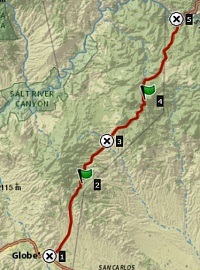
COMPLETELY PAVED: ( < Az188 Apache - Globe s(u) | US60 Jones Water - Globe s(u) > ) US60 Jones Water - Salt River Canyon s(u) x2 , additional out and back: Jones Water campground <> US60 north <> US60 Jones Water - Salt River Canyon s(u) <> bridge over Salt River <> up north side of Canyon << turnaroud point at parking lot at ~4720ft: 55.1miles with ~6380ft of climbing in 5:36hrs (garmin etrex32x r4:24.12.22) 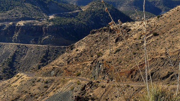 |
|
|
advertisement |
|
|
advertisement |