| |
| |
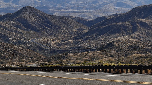
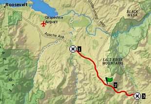
This is the main access to a
large reservoir, in weekend commuting distance
to Phoenix, south of Globe. Consequently this
highway does not get traffic to fill out its
lanes or shoulders at other times. The large
lanes, huge shoulders and superwide rumble
strips give that impression of being created
for towing houseboats and other motorized
paraphernalia. But the only decent time to
bike over it is really in the colder months,
and at that time - I barely perceived any
traffic at all. The result is a nice road bike
summit, albeit over wide, rough pavement and
shoulders covered with rocks and rumble
strips.
From South.
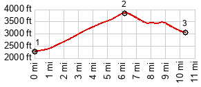
I started the elevation profile somewhere
along the lake. After all, what could be lower
than the lake, without overthinking the
situation. Well - huge lakes in the dessert are
always suspicious. This is a reservoir with
water for Phoenix and a dam. Not far from this
summit the road named Appache Trail follows the
water to the city, but high up in the
intervening hills. But immediately after
diverging from Az188, the Apache Trail first
descends to the bottom of the dam, and from
there the profile could have been several
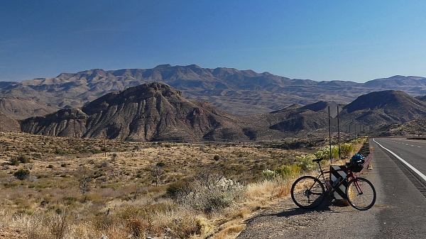
hundred feet higher. Az188 stays far away from the lake, as it rolls across the dessert arroyos. There is one last arroyo to cross at the town Roosevelt. The only evidence of the town from Az188 is a tourist grocery store. The road climbs to the top, using no turns that would cause a motorized vehicle to slow down. But the views certainly made me slow down and turn around. The junction with the paved road on the east side of the lake is quite a little shoulder summit climb in itself.
From
North. (also described upwards) After
turning off US60, Az191 is actually slightly
uphill even though it The top has an elevation sign, but nothing that designates this a summit, even though my map labels it as "The Summit"
Dayride with this point as
highest summit:
COMPLETELY PAVED: ( < Az88 Apache Trail s(u)-3 | US60 Jones Water - Salt River Canyon s(u) >) Az188 Roosevelt - Globe s(u) x2: near jct FR400 Az188 <> Az`188 south <> Az`88 Roosevelt - Globe s(u) > US60 east << turnaround point in Globe with several miles of sightseeing detours in the area: 60.3miles with 4280ft of climbing in 5:21hrs (garmin etrex32x r4:24.12.18) Notes: record warm temperatures with highs in the 80, and the first very windy day for a long time. - Best camping weather since i left beginning September. - US60 south of Globe has way too much traffic these days to be considered a "good bicycling route". - On Az188 I met Dave, 71 years old and touring the old way, as professed by him, pedal clips, paper maps, no gps, but a dedicated mp3 player, - one more dedicated painter riding from New Jersey, on the road since September, after taking care of his mother for 5 bicycle-less years. |
|
|
advertisement |
|
|
advertisement |