| |
| |
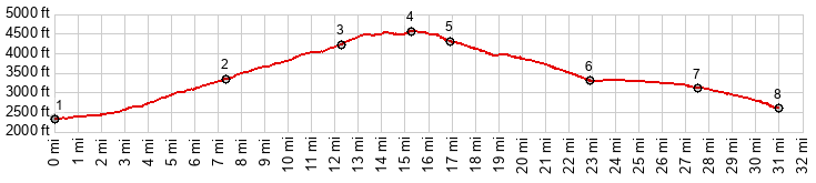
The Tuscon side of the climb to
the two way summit on Lemmon Highway does not
have any other approach options. It's the
highway, or nothing. Mt Lemmon Rd from Oracle
on the other hand has many options for the
lower portion of the largely unpaved road.
This is the lowest one of them all, and the
route shown on the profile is actually
completely paved. While the northern approach
via Az77 is definitely not ideal, and I am
still looking for an option to replace it with
something better and gravelly, the southern
approach via Webb Rd just may be my favorite
little paved climb in Arizona.
The climb on this side is far less
pleasant than the Webb Rd side, due to traffic,
and the absence of a shoulder at places where it
is needed the most. There is no problem on the
lower portion of the road through Mammoth. But
it can get unpleasant further up, especially the
last part between the jct with Verterans
Memorial Blvd and the turnoff onto Amercan Blvd
into Oracle. I tried an alternate via the
abandoned Old Tiger Rd, but was stopped by a
locked gate after about 500ft of climbing. The
map still has some other unexplored gravel
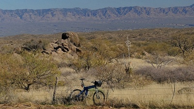
alternatives in sight. That being said, the view across
the dessert and the San Pedro Valley onto the
tiretrack patterned cliffs of the Galiuro
Mountains is fairly spellbinding, even if there
are only old trailers, some garbage and the
parking lot of a Dollar General store in the
foreground. Approaching Oracle the traffic is
history. The turnoff onto American Blvd, follows
soon, and without any visual signs of Oracle.
The road rolls along on the lowest portion of Mt
Lemmon Rd, and then summits without much change
in the scenery,
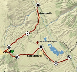
Dayride with this point as
highest summit:
PARTIALLY PAVED / UNPAVED ( < Mt Lemmon Rd via FR4450 | Az88 Apache Trail s(u)-1 > ) Mt Lemmon Rd via Webb Rd(sh) , additional out and back: jct Veterans Memorial Blvd - Black Hills Mine Rd > Veterans Memorial Blve east > River Rd north with several out and back exploratory detours, including one that was a little longer up Copper Canyon Rd > jct with Az77 <> ~2miles[one way out and back on Az77 north >> Az66 west <> Mammoth <> out and back on Old Tiger Mine Rd with turnaround point at locked gate >> Az77 west > Mt Lemmon Rd west > Mt Lemmon Rd via Webb Rd(sh) > Webb Rd east > Verterans Memorial Blvd back to starting point at jct Veterans Memorial Blvd - Black Hills Mine Rd: 56.5miles with 3730ft of climbing in 5:04hrs (garmin etrex 32x m6:24.12.09) |
 From South. (described
downwards) The roll down takes a scenic turn
after the turnoff onto Webb Rd. The absence of
traffic compared to Az77 is a pleasant shock.
But the stunning far views of the Galiuro Mtns
behind a carpet of Saguaro cacti help get over
it. The decent takes a rest when turning right
onto the mysteriously wide Veterans Memorial
Blvd. I have no objections to the wide road with
the monumental shoulder. It seems like something
that leads to a newly constructed capital of a
jungle banana republic, just with cactus scenery
instead of jungle. In any case it's beautiful
and perfect for speeding along. Surprisingly the
road suddenly takes a 90 degree turn to the left
before the final 500ft descent to the San Pedro
River and its imaginary water. The cactus scene
approaching the river is the best part of any
bike tour that includes this part. Pavement ends
here, though the roads in both directions along
the river valley remain smooth and hard (and
without signs of water)
From South. (described
downwards) The roll down takes a scenic turn
after the turnoff onto Webb Rd. The absence of
traffic compared to Az77 is a pleasant shock.
But the stunning far views of the Galiuro Mtns
behind a carpet of Saguaro cacti help get over
it. The decent takes a rest when turning right
onto the mysteriously wide Veterans Memorial
Blvd. I have no objections to the wide road with
the monumental shoulder. It seems like something
that leads to a newly constructed capital of a
jungle banana republic, just with cactus scenery
instead of jungle. In any case it's beautiful
and perfect for speeding along. Surprisingly the
road suddenly takes a 90 degree turn to the left
before the final 500ft descent to the San Pedro
River and its imaginary water. The cactus scene
approaching the river is the best part of any
bike tour that includes this part. Pavement ends
here, though the roads in both directions along
the river valley remain smooth and hard (and
without signs of water)|
|
advertisement |
|
|
advertisement |