| |
| |
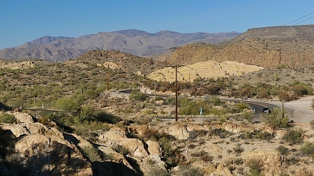
This is a very atypical road for
Arizona. The horizon does not play a major
roll here. Instead this fairly narrow road
follows a historic Indian trail over several
small summit points. This is the easternmost
summit, reachable in a day ride from the
Pheonix metro area.
But once these homes are behind,
so is most of the traffic. Steering wheels as
well as handle bars get a lot more use after
this. This is a very small climb, but you never
know if that was it, or if there is another bump
behind that next turn, behind that next
rock outcrop, under the vista of the next
blinding rock, in order to lead just a few feet
higher. Unfortunately a power line is present in
just about every photograph I am tempted to
take. But if that's reality, so be it.
From East. (described
downwards) There are so many turns and bumps in
the road, you forget if you are going up or
down. But finally a new sight appears. a lake
between the rocks with actual water in it,
Canyon Lake.
Dayride with this point as
highest summit
COMPLETELY PAVED: ( < Mt Lemmon Rd via Webb Rd s(u) | Az88 Apache Trail s(u)-2 > ) Az88 Apache Trail: Apache Jct - Tortilla Flat s(u) x2 , Usery Pass x2 , addtional out and back : near Canyon Lake on Az88 > Az88 west > Az88 Aoache Trail: Apache Jct - Tortiall Flat s(u) > Lost Dutchman Blvd west <> Idaho Rd north <> out and back to end of pavement on Idaho Rd north >> Mc Kellps Blvd west > Dutchman Blvd west > jct with Usery Path Rd <> out and back on Dutchman Blvd to jct with Loop202 >> Usery Pass > Bush Highway east to turnaround point at Water User Rec Site << Bush Highway west > Usery Pass > McKellps Rd east > Jenson St east > Brown Blvd south > Adobe St east > Superstition Blvd north-east > Az88 Apache Trail: Apache Jct - Tortilla Flat s(u) > back to startingpoint near Canyon Lake on Az88: 68.4miles with 3760ft of climbing in 5:39hrs (garmin etrex32x r4:24.12.12). Notes: perfect weather with high of 72degrees |
 Approaches
|
|
advertisement |
|
|
advertisement |