| |
| |
Mt Lemmon Rd via FR4450 The Mt Lemmon Rd is FR38 up the
Oracle side of the Catalina Mountains. This
road is not to be confused with the Mt Lemmon
Highway, which is paved all the way to the top
of the mountain from the Tuscon side, and a
popular road ride. FR38 connects with the Mt
Lemmon Highway. But this point is a shoulder
point, 2000ft below, where two lower approach
options meet, and thus form a shoulder summit,
when combined together in a single ride. One
approach is the obvious one over Mt Lemmon Rd.
The other one is actually a more direct
approach to the top of the mountain.
But the only reason the road
behaves so well is the Peppersauce pay -
campground. After that, all bets are off, and
the rocks are plentiful, though yet somewhat
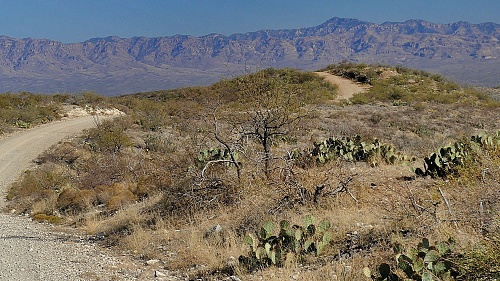
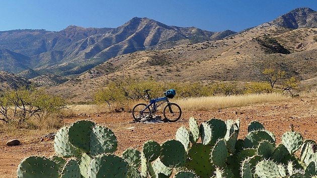
limited in size. Traversing now on a fairly
rough road on this high alluvial fan with
grandiose mountains in both directions, and
limitless plains of cacti are a very scenic
experience. To get across a low wash the road
drops 400ft only to climb 300 back up, just to
drop more than 500ft from the first high point.
This fact makes the first point a lower summit
point on FR38. So much for the description of a
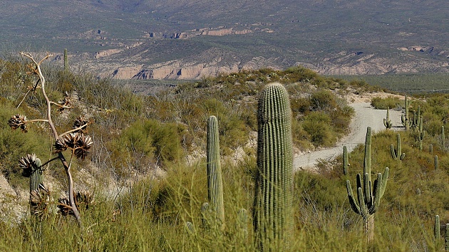
point that really belongs into a separate page. FR38 now seems to have found the
canyon it wants to ascend direction Mt Lemmon.
Surprisingly the surface becomes somewhat better
as the road curves around the lower grassy
hills, below a plainly visible road cut above.
The jct with FR4450 is signed, and the highest
point. The real climbing and the traverses of
FR38 to the Mt Lemmon Highway are still far
above.
 From South.
(described downwards) This descend has a few
uphills in it too. But going up, I think this is
a more efficient way to get to this shoulder
point, or higher points on Mt Lemmon, even if
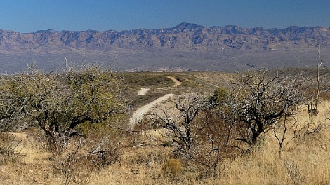
this side contains no pavement. The first steep
downhill leads into a short protected canyon
with lots of shade, followed by an equally short
climb onto a gentle ridge with great views in
270 degrees. In order to stay somewhere near the
top of this alluvial fan roof, the road
exercises in more small ups and downs. Even
though the descend is fast and straight, it
still requires time for the scenery to change.
But slowly the Galuro Mtns to the east take on
more detail in the ever so slight haze. The
cacti on the slanted plains in the distance
become countable, while the Catalina Mtns behind
turn more and more into a distant flat black
cutout. Before reconnecting to pavement of the
Veterans Memorial Highway, the road has to
accomplish a 90 degree change of direction to
the north. It does this with two switchbacks, in
order to cross on more dessert wash. The rest is
a straight roller coaster with a small elevation
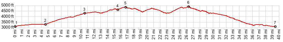
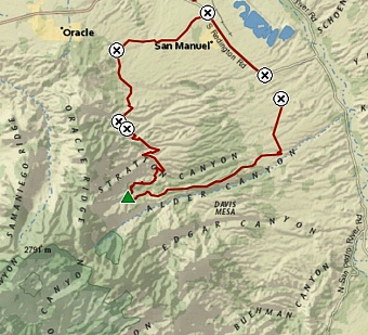
loss heading north. Dayride with this point as highest summit PARTIALLY PAVED / UNPAVED ( < Mt Lemmon Hiway s(u) | Mt Lemmon Rd via Webb Rd s(u) > ) Mt Lemmon Rd via FR4450, FE38 Mt Lemon Rd lower summit s(u) , addtional out and back: jct Veterans Memorial Blvd - FR4450 Black Mines Rd > Veterans Mem Blvd north > Webb Rd west > FR38 Mt Lemmon Rd soutb > FR38 Mt Lemmon Rd lower summit s(u) > FR38 - FR4450 Catalina Mtns(sh) <> out and back up FR38 Mt Lemon Rd to turnaround point at ~5350ft > down FR4450 > back to starting point at jct Veterans Memorial Blvd - FR4450: 45.1miles with 4210ft of climbing in 5:04hrs (garmin etrex32x m6:24.12.08) Notes: the original plan was to climb to Mt Lemon on FR38. But the many ups and downs and the possibility of an alternate way down made me look for an alternate lower approach instead. Today's high:72 degrees |
|
|
advertisement |
|
|
advertisementZ |