| |
| |
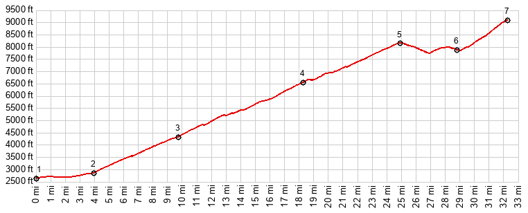
This is the most famous item in
"Arizona's Trifecta of Out and Back Mountain
road climbs". It's not the steepest. But
it is the highest completely paved climb, and
I think it is also is the most
scenically interesting of the paved parts of
the the three. Interesting light conditions on
the particular day, that I did this ride,
played a role in this impression. Topologically speaking, there
are a few more points to mention. An old,
unpaved road from the north meets the upper
portion of the new highway. So there is
actually a two-way summit, not far from where
the two meet, located on the new highway. I is
bikable, but compared to the out and back
climb on the paved road, biking this is a rare
experience indeed. But even the modern highway
descend more than 300ft from an unnamed summit
point where Whitehorse campground is located,
before meeting the old gravel road and then
climbing to the top of the out-and-back
summit. I am calling that point near
Whitehorse campground Mt Lemmon Highway s(u),
and I am listing two crossings of Mt Lemmon
Hwy s(u), for a ride that is really a
completely paved ride out and back to Mount
Lemmon(ow). This is to be consistent, and
apply the same rules for what makes a summit
crossing for much smaller summits.
When coming back down in the last
light of day this fast, last decent, it feels
like a plain finally approaching a runway. The a
grid pattern below, highlighted by points of
light in the dusk, is made up of real estate
investments. But going up this same section is
just the initial warm up to a long climb. The
entire road is engineered with wide lanes,
uniform grades that never get extremely steep.
In almost all places the road has a fairly wide
shoulder without rumble strips. The first fine
far views come a few miles after the first NF
campground. This is the rocky world of Thimble
Peak, Rose Peak and the canyons leading up to it
from the south. Amongst the many vista-pulloffs,
the most popular one with motorists seems to be
Windy Point. Not slighting its scenic beauty,
maybe one big reason for this is the presence of
toilets. Actually - this is the beginning, of
what to me is the most interesting part of the
road. A switchback leads up onto a ridge, with a
far view direction east, which is especially
fascinating during late light, but also a view
west and the world of rock towers, and piled up
rocks through which the road negotiates its way
upward with one long ramp into a higher world of
trees and shade. Between here and the top you have
to look for the far world below through port
holes in a a dense forest. An exception to this
is the first view west into the vastness of the
San Pedro Valley. The highest point of the two
way summit is reached near the turnoff to the
Whitetail campground. 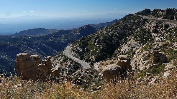 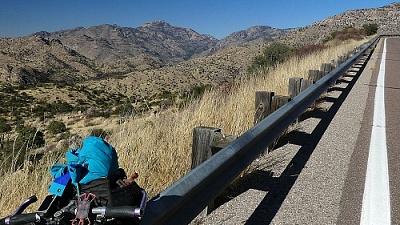
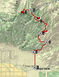
Slideshow
of section: Tucson to the two way summit
The Out-And-Back Summit to
Mount Lemmon.
Near the Oracle turnoff the
road traverses for a while along a sometimes
open ridge with views direction Oracle. Then the
rest of the climb to the peak is in dense
forest. The small collection of ski-homes in
Summerhaven is a very short downhill off the
road to the peak itself.
Road signs do a fine job in
understating the climb to the top of the
mountain, and thus coaxing the rider all the way
to the top, by understating the amount of effort
required. The signs only specify the distance to
the bottom of the ski area, but do not mention
this fact. Granted - this is not Vail Mountain,
and that is a good thing for many reasons. Once
you get to the tiny parking area in the forest,
it is only another 1.5 miles of steep climbing
to the top of Mount Lemmon. The rest of
the climb may not a actually be that hard, but
after 7000ft of climbing to get here, it sure
seemed that way. On a 6th of December it was the
only stretch of road with remnants of snow, next
to the road but not on it. The road ends on top
of the peak in the forest, at an observatory. If
there are far views from here, it takes a while
to walk to them. A much better vantage point is
not so obvious. It is not at the various
pay-parking lots , but instead at the unpaved
turnoff to the previous observatory, a small
distance below the summit - great views in 180
degrees. Some of the pictures in the slideshow
were taken there. Dayride with this point as
highest summit: Slideshow of
section: Two way summit to the
out-and-back top-of-mountain summit
|
|
|
advertisement |
|
|
advertisement |