| |
| |
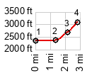
This is a great little viewpoint
over Tuscon and the Santa Catalina Mountains
from the west side of town. It's only 700ft to
the top, and that in only two miles. If you
blink, you might miss the elevation profile.
But you can't miss the grade if you ride or
walk. I am not 100 percent certain if this
road is actually open to bicycles, but nobody
seemed to mind. But then - I walked a good
part of it.
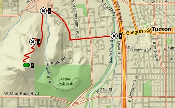
But actually there are way too
many curves in this road, for it to become a
major one. And the uphill grade is also an
argument to even walk the bike at times, before
it rolls backwards. The scenes with the Saguaro
cacti in the foreground are stunning. The Santa
Catalina Mountains behind the spread of square
pattern streets are a welcome limit on the
geometrical patterns below. The second part of
the climb, past the parking lot (how did these
cars get up here?) is especially steep and
rewarding. Unfortunately the cacti make a very
desiccated and ill appearance. How much longer
will they be here?
Dayride with this point as
highest out-and-back summit and no two way
summits:
COMPLETELY PAVED: ( < Gates Pass | Mt Lemmon Hiway s(u) > ) near jct Old Ajo Highway - Camino Verde > Az86 west > bikepath along Santa Cruz RIver north, mostly on west side of river > bikepath along Rilito River east, both sides of river > Craycroft Rd west > Speedway Blvd west > detours around downtown > jct with bikepath along Santa Cruz River <> out and bck to top of Tumamoc Hill Rd(ow) > bikepath along Santa Cruz south > Az86 east > back to starting point near jct Old Ajo Highway - Camino Verde: 63.1miles with 1900ft of climbing in 5:07hrs (garmin etrex32x r4:24.12.03). Notes: seems like it's getting warmer every day |
|
|
advertisement |
|
|
advertisement |