| |
| |
This is a really popular road
ride for Tusconics. The climb is gentle, yet
noticable, traversing along the lower alluvial
fans of Sierrita Mtns. And it has a bona fide
tourist attraction on its north end: the
historic Spanish San Xavier mission, adorned
in white-Spanish-Village white. Alternatively,
approaching this tourist stop from the south
over this summit, offers a quiet peaceful
workout before the touristic confrontation.
Enough with the cacti for now
after this junction. They have been replaced by
mine tailings for the forseeable future. But an
absence of traffic is offered as consolation. Up
on the left in the Sierrita Mountais is a radio
tower, I want to explore closer someday, but for
now the gentle slope and pleasant views over
onto the Santa Rita Mountains are also very
nice. Approaching an inconspicuous high point a
well named "helmet peak" finally acts as
landmark and transtion to throw the viewscape to
flat old Tuscon open. From North.
The decent on this side seems even
shallower, but the cacti are back to beautify
the flatness. Entering the Tohono-Ooodham
resevation is an interesting experience in
seeing how people live. The historic San Xavier
Mission is an extra half a mile or so off the
loop. On the map it looks like there is a way to
connect to the bike path along the Santa Cruz
River from here. Unfortunately I wasn't aware of
that, if it in fact exists. The generic modern
building surrounding the mission forms an abrupt
transition, from the interesting architecture of
the church itself. As usual, there are signs
forbidding photography of the things that would
be most interesting to photograph. There is on
exception: the interior of the church makes for
some fantastic images. The profile ends here.
Continuing further north on the same road, the
traffic becomes much worse. But there may be
other possibilities that I did not have time to
check out. 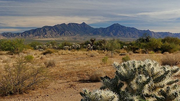
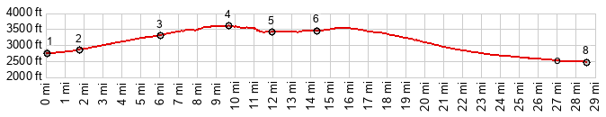
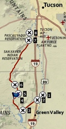
Dayride with this point as
highest summit
COMPLETELY PAVED: ( < FR4058 - FR231 Santa Rita Mtns | Kitt Peak(ow) > ) Mission Rd s(u) , :jct: Duvall Mine Rd - Continental Rd(sh): Whitehouse Canyon Rd at ~3460ft > White House Canyon Rd west > Continental Rd west > Duvall Mine Rd west > Mission Rd north > Mission Rd s(u) <> out and back on San Xavier Rd to Mission with small detours >> Valencia Rd east > Tucson - Nogales Highway south > Old Nogales Highway south > Tucson Nogales HIghway south > Duvall Mine Rd west > jct Duvall Mine Rd - Continental Rd(sh) > Continental Rd east > back to startingpoint on White House Canyon Rd: 70.7miles with 2680ft of climbing in 5:23hrs (garmin etrex32x r4:24.11.28) 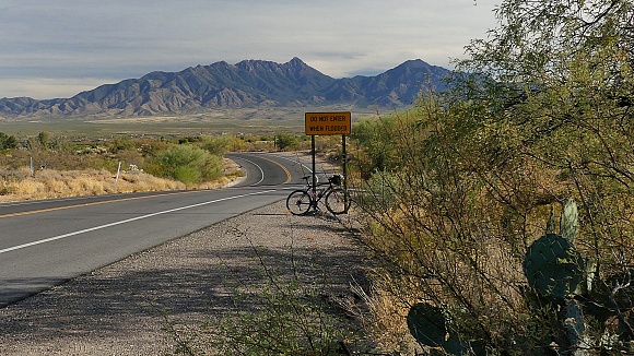 |
|
|
advertisement |
|
|
advertisement |