| |
| |
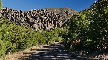
Massai Point s(u) This "point" we are talking
about is a scenic lookout spot inside
Chiracahua National Monument, the end of the
road, and the highest point on it: great
views, excellent pavement. a far distance from
any business infrastructure, a wonderful
little bike climb.
You can roughly divide this little
climb into two sections. The first part stays on
the canyon floor. Rock columns, spires and
balanced rocks start to show up with regularity
in the upper field of view, and then also along
the road of this narrow canyon. Some distance
past the visitor center the road traverses up
the canyon and climbs one of the lower ridges
between the main group of the Chiricahua
Mountains and the Turkey Creek Caldera. Signs at
Massai Point explain the significance of this
blown up volcano in creating this magical
landscape with all those spires. But before
getting there, another spur leads to two
trailheads, one of them the short 2 mile hike up
to Sugarloaf Lookout. This walk was really the
high point during my trip up here, in every
sense of the word, and so I included a separate
slide show of the walking portion. Massai Point itself includes a
small viewing platform constructed from natural
stone of the area, a piece of great workmanship
that fits perfectly into the landscape and
enriches it, a piece that just screams "Civil
Conservation Corps". Slideshow of Road Approach
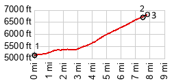
 Dayride with this
point as one-way summit (and no two way
summits) Dayride with this
point as one-way summit (and no two way
summits)( < Onion Saddle | Middlemarch Pass > ) FR42 a mile or two inside Chiricuahua NF > FR42 west > Bonita Canyon Rd west <> out and back to Sugarloaf trailhead <> separate out and back to Masai Point(ow) >> back down Bonita Canyon Rd east > back to starting point on FR42: 27.2miles with 2490ft of climbing (garmin etrex32x m6:24.11.14) Notes: day also included a hike to the Sugarloaf Mtn Lookout bike+hike: 29.2miles with 2980ft of climbing. Batteries in gps did not last the whole tour. So there are no times, and the track is partially reconstructed Slideshow
of the walking part of this day
|
|
|
advertisement |
|
|
advertisement |