| |
| |
When I first looked at this section of the Apache Trail (a road) on the map, I thought there were no summits on it at all, just a bunch of rollers that really don't add up to much elevation gain, except as a rolling approach to the steep climb up from Fish Creek. Boy - was I wrong. Now - actually having ridden this section, there are any number of summits and additional potential summit points, when you consider all the access points to Apache Lake and the stream that feeds it. Applying the 300ft/500ft
criteria, from the profile it is clear that
Az88 itself traverses two summits between
Roosevelt Lake and the crossing of Lewis and
Pranty Creek (slightly lower than the Fish
Creek crossing).
Approaches Turning off Az188 onto Az88, the
road passes two scenic dam-view gazebos and
quickly drops to the waterlevel on other side of
the dam. This already amounts to ~300ft. The frst 200ft climb aims back
towards the same picturesque elevation water of
the reservoir, After that the road diverts into
the hills south of another reservoir, Apache
Lake. From s(u)-4, the next giant rollers are
pretty evident. In the blinding, frontal light
they resemble a rolled out roll of toilet paper,
curving between power lines, over dessert hills.
The next climb actually leads a bit higher, but
it drops less than 300ft, and so I consider it
part of s(u)-3, which is the actual subject of
this page.
From
West. (also described upwards).
Just a short shallow climb, involving two more
signed one-lane bridges, both not nearly as
spectacular as the one over Fish Creek, which is
part of the approach to the highest point on the
Apache Trail.
Dayride with this point as
highest summit
PARTIALLY PAVED / UNPAVED ( < Az88 Apache Trail s(u)-2 | Az188 Roosevelt - Globe s(u) > ) Az88 Apache Trail s(u)-3 x2 , Az88 Apache Trail s(u)-4 x2: jct Az188 - FR83 <> Az188 north <> Az88 west <> Az88 Apache Trail s(u)-3 x2 <> Az88 Apache Trail s(u)-4 x2 << turnararound point on Az88 at first signed one lane bridge at ~2180ft: 46/2miles with 5000ft of climbing in 5:18hrs (garmin etrex32x m6:24.12.17) Notes: on the way out I met Peace from painterofparks.com, heading over the Apache Trail to Phoenix and stopping regularly by the wayside to do a painting |
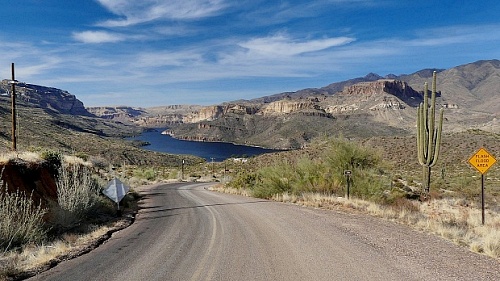 Climbing
this next set of steps culminating in s(u)-3
becomes increasingly scenic, due to height
gained over Apache Lake. A small lip of trailers
at its shore provides scale to the four peaks
behind it. There is steep one mile descent to
the lake which allows defining more summit
points along the route. The best part comes
shortly after this steep turnoff when the power
lines disappear from the vista and the image
becomes a whole. But this is also the point
where the surface turns into a sandy washboard.
However, road work is happening all along the
route. So after December 2024 this has probably
changed. From the summit you only catch a first
glimpse of the real climb up from Fish Creek.
Climbing
this next set of steps culminating in s(u)-3
becomes increasingly scenic, due to height
gained over Apache Lake. A small lip of trailers
at its shore provides scale to the four peaks
behind it. There is steep one mile descent to
the lake which allows defining more summit
points along the route. The best part comes
shortly after this steep turnoff when the power
lines disappear from the vista and the image
becomes a whole. But this is also the point
where the surface turns into a sandy washboard.
However, road work is happening all along the
route. So after December 2024 this has probably
changed. From the summit you only catch a first
glimpse of the real climb up from Fish Creek. |
|
advertisement |
|
|
advertisement |