| |
| |
This is the highest and most
sensational section of the Apache Trail on
Az88. The summit marks the highest point
between Apache Junction and Roosevelt Lake and
the transition between pavement and gravel
From here a beautiful climb starts, that increases the viewshed east at a constant rate. At this point things seem perfect, great surface with barely to no traffic, fantastic landscapes. The temperate december day is warming up so that I shed the last jacket - none of the usual headaches like rumble strips or frost heaves, no 2 inch cracks in the pavement that makes the gps fall off the handlebar, just incredibly far views, with a plethora of cacti to choose from for every photograph. And then it all ends. I should
have known. The absence of traffic is a dead
give-away that the road will turn to dirt. I
really should have known that. It's only 200ft
more climbing to the summit, where a short walk
leads out on a neck of sorts, that is viewpoint
over a canyon, as well as the wild drop ahead
that the road negotiates. Slideshow
of Western Approach and the summit area
From East. (described
downwards) This side is actually quite small,
but also a very rugged road construction, that
feels like a different country. Rock overhangs
over the road like this are almost nonexistent
in the US. But there is definitely one here.
Also the guard rails are a more straight forward
construction, that fits much better in the
environment. The steep shelf road descends to a
bridge between cliffs in deep shadow. The
absence of sunlight causes a sudden drop in
temperature. Later, back in warming sunlight,
two more narrow bridges cross Sheep Creek. But
that is already past the low point, heading up
the next Apache Trail summit. Slideshow
of Eastern Approach
Dayride with this point as
highest summit:
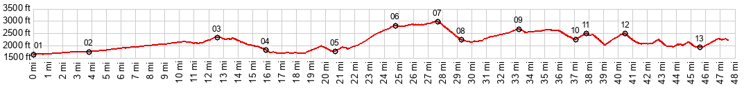
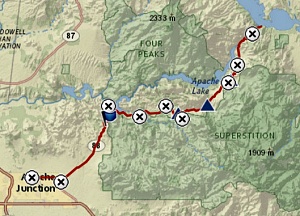
PARTIALLY PAVED UNPAVED. ( < Az88 Apache Trail s(u)-1 | Az88 Apache Trail s(u)-3 >) Az88 Apache Trail s(u):-2 Tortilla Flat - Fish Creek x2: near 2 miles west of Canyon Lake <> Canyon Lake <> Az88 Apache Trail s(u): Tortilla Flat - Fish Creek x2 <> turnaround point past low point at second bridge over Lewis and Pranty Creek: 31.4miles with 3560ft of climbing in 3:45hrs (garmin etrex32x r4:24.12.13) Notes: short ride, turnaround due to sand and washboard not so great for the road bike 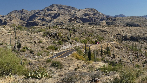 |
|
|
advertisement |
|
|
advertisement |