| |
| |
Wasatch Connector Trail
Sawatch Mountains - Wasatch
Mountains. It all can be very confusing, at least
for me. This is the way I see it:
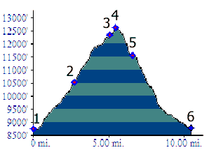
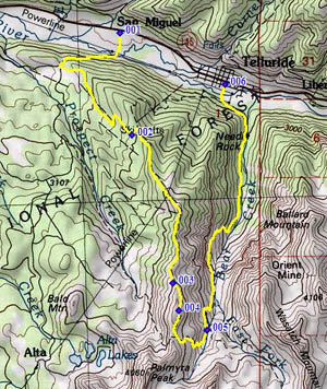
Most everybody agrees, that the Wasatch Mountains are in Utah and the Sawatch Mountains are in Colorado. But there is also a singular wayward Wasatch Mountain, that seems to have landed in Colorado, near Telluride in the San Juan Mountains to be more exact. A loop trail crosses this mountain, labeled as Wasatch Trail on maps. The summit is informally, often called Wasatch Pass. But to make things even more confusing, there is also a Wasatch Connector Trail, which connects the former loop with the network of trails in the Telluride Ski area. Its highest point is near where it connects to the ski area, a couple of hundred feet short of the highest point, that can be reached with a lift. The loop shown here, goes over this summit, and does not go over the still higher Wasatch Pass. Instead it descends along Bear Creek back into Telluride. For me, much of this was a hike your bike kinda bikehike.
From West. The profile starts at the
valley floor in Telluride. But once you are in
Telluride the easiest way to start this short
excursion is with a ride on the free gondola to St
Sophia Station at 10535ft. Bicycling this first
section inside the ski area is not legal, even
though there are plenty of suitable tracks visible
from the gondola. The profile shows the most
direct way up that is bikable. It is the Boomerang
Trail from San Miguel (located down a couple of
miles on the Telluride Co145 spur). However the
easiest way up, under your own power, is probably
pavement to Mountain Village, and then the
Boulevard Trail and Village Trail to this ski lift
station. Next to the ski lift station an attendant in a
tiny hut will be happy to point you to the
See-Forever Trail. Even without that help, it is
pretty obvious, follow the ridge line where ever
possible to the west. If the route doesn't follow
the ridgeline exactly, there will soon be a
connecting trail to the ridgeline. This is
definitely not the most bikeable trail up here,
probably the least bikeable. At one point early on
the ascent, the easiest way is to walk the wooden
stairs on the side of the trail, while pushing the
bike next to the stairs. Later on I still had to
resort to pushing the bike, traversing the ski
slope, only to discover that there was a more
readily negotiable road next to my ski run. As
already said - not very bikeable, but there are
some sections that are ridable. They just go by a
whole lot faster. But the route does have the best
views, especially across to Imogene Pass and
that incredible amphitheater around Telluride. To
the south is the whole Mount Wilsons panorama,
albeit on top of scenery cut to pieces by ski
runs. After passing a vino bar, or some such ski
thing, it is not far to the turnoff onto the
Wasatch Connector Trail. Signs point you in the
right direction, if you are in danger of being
mislead by a descending ski run. But there is no
sign at the actual trail turnoff. It is located
directly under an impossibly steep, short slope to
the highest lift station around. It sure seemed
like this turnoff was the highest point on the
trip. However, according to topo maps the
connector trail rises a little bit while it
contours towards Silver Mountain.
Pictures: top group of four: lower left
picture taken on the Wasatch Connector Trail. The
other three along Bear Creek on the eastern side.
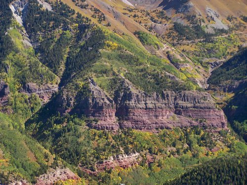
Picture above shows the lower Imogene Pass road,
as seen from the ski area trail. Dayrides with this point as highest summit: Wasatch Connector Trail s(u) , additional out and backs: Society Turn (Telluride turnoff on Co145) > bike trail into Telluride > gondola ride to St Sophia Station > See Forever Trail or parallel route > Wasatch Connector Trail s(u) > down Wasatch Connector Trail <> out and back on Wasatch Trail as far as the end of the first steep part > down Bear Creek Trail > bike path back to starting point: 20.4miles with 2630ft of climbing in 3:43hours (VDO MC1.0 m3:11.9.23). Notes: I had every intention of biking the whole way up. but found out this was not possible without making a big detour until I was in Telluride - what the heck, it's a free gondola, and my bike survived it too. Also - Wasatch Pass was visible after out and back from jct with Wasatch Connector Trail. It was covered in snow on this Sept 23. First snow was on about Sept 16, but not yet melted.
|
 Approaches
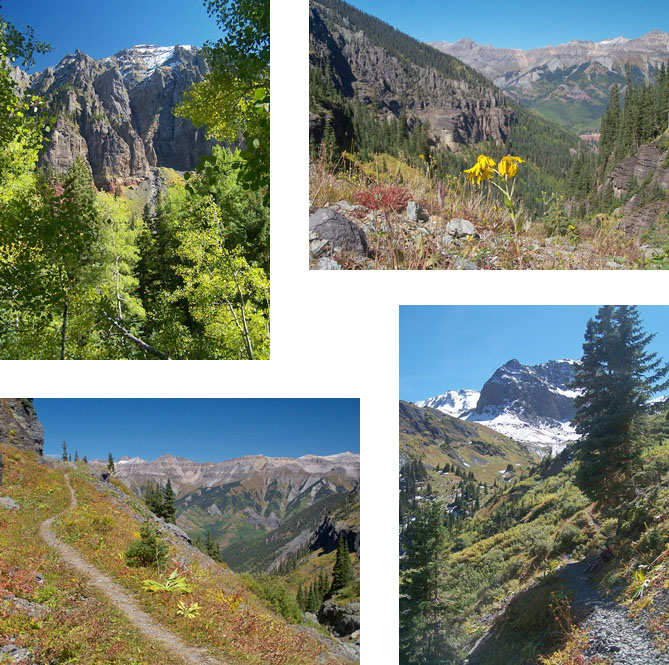
|
|
advertisement |
|
|
advertisement |