| |
|
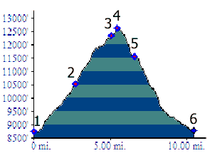
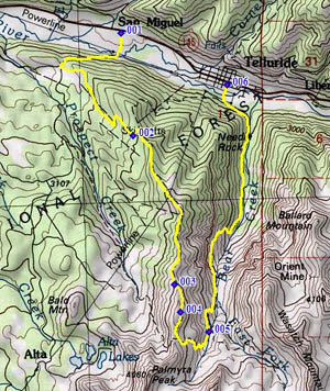
1.(8750ft,mile00) START-END WEST: Boomerang Road leave Co145 at San Miguel
2.(10535ft,mile03) START-END WEST ALTERNATE: Station St Sophia (ski lift)
3.(12356ft,mile05) Wasatch Connector Trail leaves See Forver Trail below Gold Hill
4.(12630ft,mile06) TOP
5.(11580ft,mile07) jct with Wasatch Trail. Profile turns left down Bear Creek.
6.(8780ft,mile11) START-END EAST: junction Pine Street - Main Business Street, Telluride