| |
| |
Unaweep Divide
Located in extreme western
Colorado, the Unaweep Divide is a unique, paved
cycling climb that is often overlooked. The pass
never crests a ridgeline with far reaching views.
It stays in a canyon, a mysterious canyon in which
rivers seem to change direction. Of course they
really don't. Instead one water way exits through
a narrow red rock canyon, while another tumbles
down from a high snowy plateau. This togographical
puzzle has its origins in the geology of the
Colorado Plateau. The canyon was carved by an
ancestral river. Through uplift and stream capture
it was relocated to today's Gunnison River,
leaving this canyon high and dry except for runoff
that took advantage of the already existing
valley. This is one case where the canyon is much
older than the course of the stream occupying it
these days.
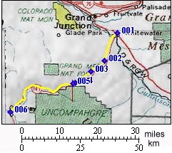
From North. The climb starts at the
junction of Co141 and US50 south east of Grand
Junction. The thin flaky rock layers flanking the
lower climb resemble a baked cherry turnover,
while across the wide dessert valley carved by the
Gunnsion River, puffy cream clouds billow over the
giant bread loaf of Grand Mesa. The climb levels
out after 8 miles. While the dirt surfaced "Divide
Road" continues to climb further up the
Uncompahgre Plateau, the road to the Unaweep
Divide seeks out the canyon of West Creek. The
straight high cliffs stand in contrast to the
small meandering creek at its bottom. Thimble Rock
near the summit is one of the rock formations
deemed worthy as being labeled by a roadside sign.
The divide itself is somewhat anticlimactic,
hardly noticeable if it wasn't for a sign, and
even that is only noticeable if traveling at a
slow pace, like a bicycle. Private residences with
large parcels of land are near the summit. 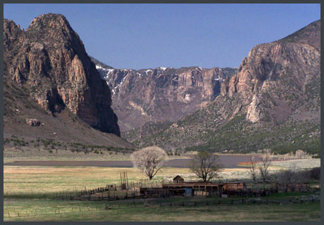 From South. The canyon leading to the
Unaweep Divide begins where Co141 enters the
Uncompahgre Plateau in Uravan. But the climb
begins many miles later in Gateway. The section
between Uravan and Gateway is actually downhill on
the average, even though a rolling valley bottom
would describe the road better. The canyon follows
the Dolores River downstream to Gateway, located
inside the deepest part of a dark red canyon with
sheer cliffs. Here the Dolores pulls an escape
trick and exits the scene by escaping to terrain
of further topographic confusion in Utah.
Meanwhile the road, still inside the main canyon,
now follows a tributary of the Dolores upstream,
West Creek. As the road leaves climbs above
Gateway, you can catch a glimpse of the La Sal
Mountains, a contrast of often snow capped rounded
mountains, behind sun baked vertical cliffs.
Immediately thereafter, the road enters its own
vertical canyon landscape, not nearly as red as
the Gateway area. Still it is easy to forget that
this not the state bordering Colorado to the west.
The summit levels out very gradually amidst more
moderate landscape.
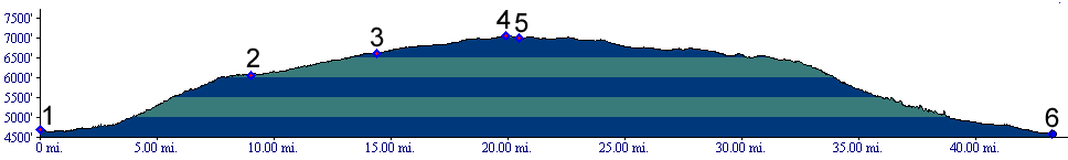
Tours Dayrides. (paved) out and back ride from the East Creek dayuse area near Westwater to Gateway and back, going over the Unaweep divide twice, measured 85 miles with 5550ft of climbing in 6.5 hours (m2:06.04.29)
|
||||||||||||||||||||||||||||||||||||||||||||||||||||||||||
 Approaches
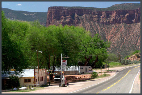
|
|
advertisement |
|
|
advertisement |