| |
| |
Salt Creek Pass
This is an obscure dirt road
crossing near Trout Creek Pass. But it does have
at least one interesting characteristic. Together
with other unpaved roads it can be used to detour
the rumble strips and possibly heavy traffic on
Trout Creek Pass. This route makes an almost out
and back detour up the lowest slopes of the
Buffalo Peaks and then merges back onto US285
slightly west of Antero Reservoir. Even though no
topo maps, forest service maps or signs in the
area give any indication, this is a named pass. It
is included in Helmuth's book "Passes of
Colorado". He sources the name back to James
Grafton Roger's "list of geographic Colorado
features".
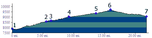
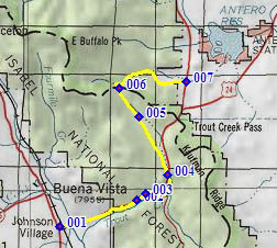
From West. The profile uses much of US285
to Trout Creek Pass, since this is the most direct
approach. When on a bicycle, especially during
heavy weekend traffic other alternatives are much
preferable. Some of these are the Midland Railroad
Grade trail, or FR376 from Buena Vista. Other dirt
road options exist south of US285. In any case,
even if approaching on US285, once you reach the
junction with FR309 (point 4), there is no more
reason to endure the 6 inch shoulder of US285. FR309 takes off on the right, and soon crosses
over onto the other side of US285. This road heads
straight for the Buffalo Peaks, with other Buena
Vista approaches branching off to the left, the Lenhardy Cufoff
s(u) and the FR311 Chubb
Park s(u). On the right of the profiled
route there is also an option that follows the
historic railroad grade through Chubb Park to the
historic summit of Trout Creek Pass. But the
profiled route on FR309 continues its dead aim for
the Buffalo Peaks, all the way to its own summit,
where it meets FR436 on the other side of a cow
gate and the route switches direction abruptly to
the east. Continuing straight up FR436 leads
further up the lower slopes of the Buffalo Peaks,
and also connects with a hiking trail that is open
to bicycles, connection with the Buffalo Meadows
Road into the Arkansas Valley. From East. (also described upwards) Just
before US285 to Trout Creek Pass starts its short
miniscule climb into a knoll of trees, the Salt
Creek dirt road branches off to the right. It
skirts along the forest. From here the far views
of the higher peaks in the Mosquito Range are the
best views on this side. The road soon enters the
forest. As FR436 stays left at a junction, the
road following Salt Creek further upstream stays
right. There is also a nice designated mtb trail
up the right fork. Dayrides with Salt Creek Pass as highest two way summit PARTIALLY PAVED / UNPAVED / OUT AND BACK HIKESalt Creek Pass, Trout Creek Pass, additional out and back : campsite near jct FR187- US285 (west of Trout Creek Pass ) > FR309 north > Salt Creek Pass <> out and back to end of FR436 towards Buffalo Peaks <> (out and back hike towards base of Buffalo Peaks) >> FR436 south > US285 west > Trout Creek Pass > back to starting point: 34.2 miles with 2930ft of climbing in 3:49hours (VDO MC1.0 m3:11.6.22) |
 Approaches
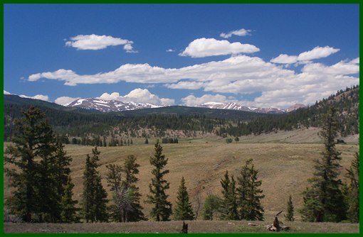
|
|
advertisement |
|
|
advertisement |