| |
|
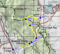
1.(7880ft,mile00) START-END EAST: US285 turns east towards Trout Creek Pass at Johnson Village
2.(8570ft,mile06) Shields Gulch dirt road on left connects with Midland Railroad Grade and Lenhardy Cutoff.
3.(8670ft,mile07) Mc Gee Gulch connects to same mtb routes as point 2. Profile goes right onto CR307 at same point.
4.(9030ft,mile09) dirt road crosses US285 and is now FR309
5.(9350ft,mile14) jct with FR311; profile continues straight
6.(9720ft,mile16) TOP
7.(9060ft,mile22) START-END WEST: jct US285 - FR436 Salt Creek Rd in South Park