| |
| |
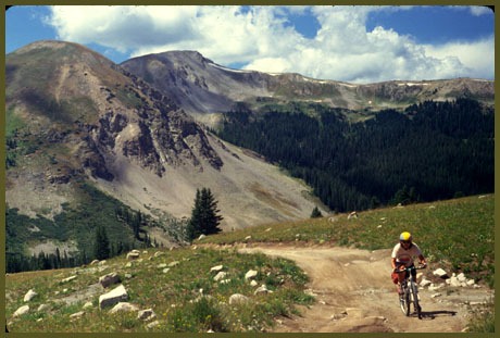
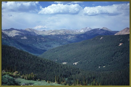
Hancock Pass
Hancock Pass is at the center of
at least six Sawatch Range passes, approaching
12000 feet in top elevation. All can be crossed
with a bicycle. On this pass a steep top makes for
a fast transition from a dense forest to a
dramatic alpine summit view. Both sides of the
pass have rocky stretches that necessitate some
walking. In spite of the roughness of this pass,
the 14er Region Mountain Bike Guide ( a free
publication available at local businesses ) has
included both sides of the pass as recommended MTB
routes since 1995.
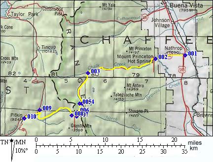
From East. A large part of the approach to Hancock Pass is common to the approach to Chalk Creek Pass, Tincup Pass and Williams Pass. A smooth dirt road leads towards the attractive old settlement of Saint Elmo. The route continues south up Chalk Creek past the site of the old mining settlements Elmo and Hancock. Here the route turns west and begins a steep two mile climb to the summit, where it opens up a dramatic summit view onto Tomichi Pass. This last stretch is only about two miles long but contains 90 percent of the rocks and gains a thousand feet. The top half mile is so rocky and steep that bicycling becomes a different set of exercises, consisting of getting on and off the bike for some, just plain walking for others, and falling on their faces for a select few.
From West. The approach to
Hancock Pass, Tomichi
Pass and Willliams
Pass pass follows a good dirt road
paralleling Quartz Creek. It is at the junction of
Williams with Hancock and Tomichi Pass that the
ridability of the route takes a nosedive. Leading
up between Mount Chapman (12756 ft) and Van Wirt
Mountain (13025ft), a trail much to steep and
rocky to bike, climbs to the summit. The single
mile of distance on the profile hides the true
amount of time that is invested in this part of
the climb. Halfways to the top, the rocks subside.
But now it is just too plain steep. Then at the
very top the trail is quite rideable. At this
point the only thing missing may be enough energy
left in the tank. Along the way it is impossible
to miss the impressive views of Tomichi Pass
slicing across Paywell Mountain, on the other side
of the valley in Silver Brittle Basin.
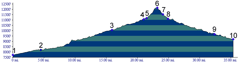
Dayride with this pass as highest
summit: Hancock Pass , Williams Pass :
Hecla Jct area > Princeton Hot Springs >
Hancock > Williams Pass > Hancock Pass >
back to starting point: 69.3miles with 6890ft of
climbing in 7.56hrs (Cateye100AT m3:5.7.6) Two Day Tour. A group ride starting near Mount Princeton Hot Springs, crossing over Tincup Pass and Cumberland Pass to Pitkin measuered 39 miles. The next day the return to the starting point over Hancock Pass measured 36 miles (m3:93.08.14-15). History Hancock pass has sometimes been
confused with Williams pass. The fact that Hancock
Pass has been called "New Williams Pass" only adds
to the confusion. The name "New Williams Pass" can
be justified by the fact that the two pass routes
only differ in a short top section. At least the
difference appears short on the map, in comparison
to a traversal of the entire profile. Even though
Williams Pass is lower, swampy conditions at the
top often make it impassable, prompting the search
of a different nearby crossing. Trail conditions conspire to favor
Hancock Pass over Williams Pass for much of the
summer and fall. Yet Williams Pass is the more
historic crossing. The earliest regular use of
Hancock Pass was around 1888 as a mining route. At
this time the Arkansas Valley already had two
railroads. Williams Pass was 8 years old, and the
reason that Williams Pass existed - namely the
alpine tunnel, was already decommissioned for five
years. An official name for the impromptu crossing
was accepted by the USGS in 1962.
Cycling. An early
mountain biking guide, first published in
1987 mentioned Hancock Pass as being
suitable for mountain biking in its
appendix, although the name was misspelled
as "Handcock Pass". (William L. Stoehr's:
Bicycling the Backcountry).
|
 Approaches
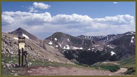
|
|
advertisement |
|
|
advertisement |