| |
| |
FR766 Fairview Mine s(u)
This little used hiking (and now
biking) summit is roughly a parallel crossing to Cumberland Pass
in the Sawatch Range. One side is a forest road
branching off the southern side of Cumberland
Pass. The other approach can either start at
Taylor Reservoir or Pitkin. I took the Taylor
Reservoir option and that is what's described. No
matter where you start, the route includes no less
than 6 miles of mostly hiking, often over rocky
steeply ascending trails. The reward is a rarely
visited pass with good views of the surrounding
peaks. There are no signs forbidding two wheeled
vehicles along this route.
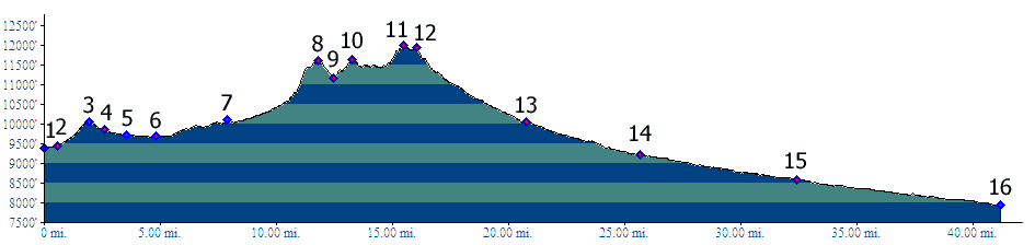
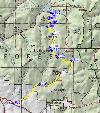
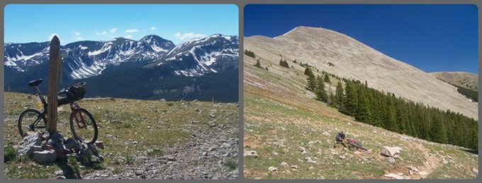
From North. The profile starts at the south end of Taylor Reservoir and follows a dirt road signed "Union Park". It follows Willow Creek, but on the opposite side as the road Tincup. Otherwise the route the Tincup road and soon turns up FR752 with the first steep "wake up" climb. The first of many nice views of the Collegiate Peaks can be seen turning to the back. Shortly after the first intermediate summit the sage plain of Union Park appears as foreground to a set of rarely visited peaks in the Sawatch Range. The route follows around the west edge of Union Park, crosses several gates at the Union cow camp, where the route designation changes to Gold Creek Trail. However this is still an easily rideable double track trail. Past the junction with the Cameron Creek Trail, the route descends a short distance and crosses some Gold Creek Puddles filled with wading cows and whatever they secrete. From here on the route is a mosquito hell, at least in June, lasting at least up to the top of Shaw Ridge. The next 7 miles to the summit go by very slowly. Several miles up Gold Creek the route becomes a barely rideable trail that climbs steeply to Shaw Ridge. At last it deviates from the creek offering some relief from the mosquitoes. At this first top the trail rejoins with Cameron Creek Trail, which has traversed a higher altitude to get to this point. Here you cross a cow gate and after a short descend on a double track trail, a sign pointing left offers a trail to Fairview Mtn. If you keep going straight here you end up in Pitkin or Ohio City, which is an alternate approach to this point. The trail from here to Fairview Mtn. is not shown
on my topo maps. A hiking trail with short
rideable stretches climbs to a low shoulder on
Fairview Mtn, maybe a hundred feet above treeline.
From here the trail traverses across the north
side of Fairview Mtn, descending a bit to go
through trees. Then it climbs steeply to the
saddle, 50 feet above and half a mile southwest of
the Fairview Mine.
From South. (described downwards). The traverse over to the mine can still be completely snow covered, even if the rest of the route is completely snow free. This is not a problem. It's easier just to go cross tundra and pick up the clearly visible forest road below the mine. Steep and rocky FR766 joins with several other tracks descending from the mountains and becomes rideable after a mile or so. Several miles later it becomes a lightning fast, enjoyable descend. At the jct with FR766.1B is a last chance to turn
around and take in a great view of the ridge you
have just descended. The road merges onto the Cumberland Pass
Road. There is no sign at this intersection.
Coming the other way this junction can be easily
mistaken for another small forest road. The
profile continues all the way down Cumberland Pass
Road to its beginning in Parlin.
A Dayride with this point as intermediate
summit is on page: 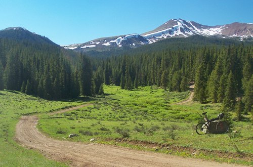 Last view back up FR766 towards the Fairview Mine summit, before descending to the Cumberland Pass Rd |
 Approaches
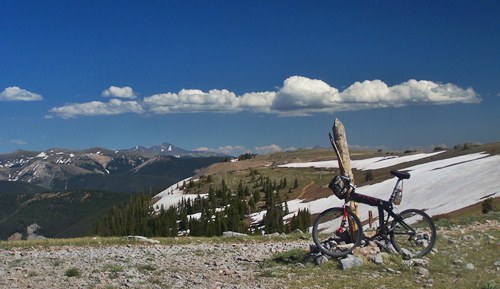
|
|
advertisement |
|
|
advertisement |