| |
| |
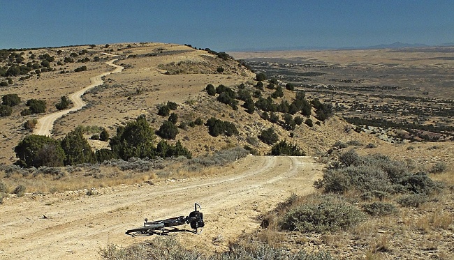
CR71 Godiva Rim s(u) The beauty of this summit is
easy to miss, and difficult to imagine
when just looking at a map. My usual
method is to look for squiggly roads or
closely bunched contour lines. None of
these can be found in this vicinity. The
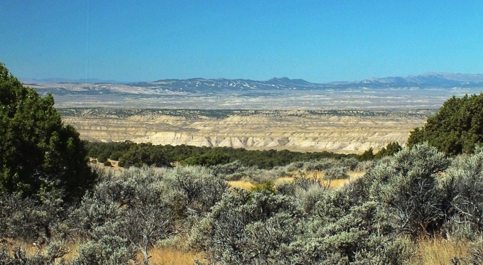
appeal here is more that of an endless
rolling plain, upon which sit superbly
sculptured monuments and ramps and buttes
and a sandy, sinuous river cuts through
it. This area is very isolated for
Colorado standards. I did see some amazing
evidence of life, but once I was more than
a mile from Co318, it was all in the form
of wild horses. Sometimes it seems that the
popularity of a bike route is inversely
proportional to the distance to the next
bike store. Scenic beauty plays a
secondary role when measuring popularity.
In this case the next bike store, I know
of is in Green River, Wyoming. Craig,
Colorado is a little closer, but I did not
see a bike store there.
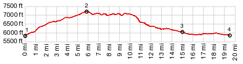
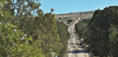
The nicely surfaced dirt road
climbs up bare grassy slopes with ever
improving views of the Little Snake River
and its sinuous course. Then the road
becomes as straight as a ruler, and has few
signs of heavy usage. It cuts straight
through a juniper forest to arrive at the
rim. Here a great panorama waits. It
includes a good view of the route just
traversed. And it follows the wedge shaped
ridge ahead back down into the valley.
Heading north there is also a little used
farm track that appears to follow the rim,
where CR71 cuts through the juniper forest -
a good reason to return with a mountain bike
someday.
From
South. (described downwards) The best
part of the ride is now to come, following
the rim heading north. There are quite a few
dips followed by short steep climbs. They
show up surprisingly well in the profile.
But the road surface is generally excellent
for unpaved road biking. Finally the road
curves north and meanders back down to CR21.
The profile continues over a short section
of this road and then turns off onto CR26 to
the Snake River.
Dayride with this point
as highest summit:
PARTIALLY PAVED / UNPAVED ( < Aspen Mtn Rd s(u) | CR45 Dry Mountain Road s(u) > ) CR71 Godiva Rim s(u) , CR26 Seven Mile Ridge(sh) , CR75 Seven Mile Ridge s(u) , CR71 a short distance from its jct with CR21 > up CR71 > CR71 Godiva Rim s(u) > CR71 north > CR21 north > CR26 west > Little Snake River crossing without bridge > CR26 south > CR26 Seven Mile Ridge(sh) > CR75 south > CR75 Seven Mile Ridge s(u) > Co318 east > CR21 north > back to starting point on CR71: 44.5miles with 3890ft of climbing in 5:15hrs (garmin etrex30 m3:20.9.29) Notes: the only paved part is maybe less than a mile on Co318. This ride contains a river crossing without a bridge (See description). A perfect late September day.
|
 CR26 continues on
the other side of the river. But a bridge to
get there is not provided. On a day in late
September it was feasible to cross the
river, by walking a short distance upstream
on the sand banks. The last crossing
involved water, that you could carry the
bike through without getting it wet. It
reached about halfways to the knees. The
most problematic part is climbing the sandy
banks of the river on the other side and
getting the bike up there. But given 15
minutes, plenty of suitable spots can be
found.
CR26 continues on
the other side of the river. But a bridge to
get there is not provided. On a day in late
September it was feasible to cross the
river, by walking a short distance upstream
on the sand banks. The last crossing
involved water, that you could carry the
bike through without getting it wet. It
reached about halfways to the knees. The
most problematic part is climbing the sandy
banks of the river on the other side and
getting the bike up there. But given 15
minutes, plenty of suitable spots can be
found.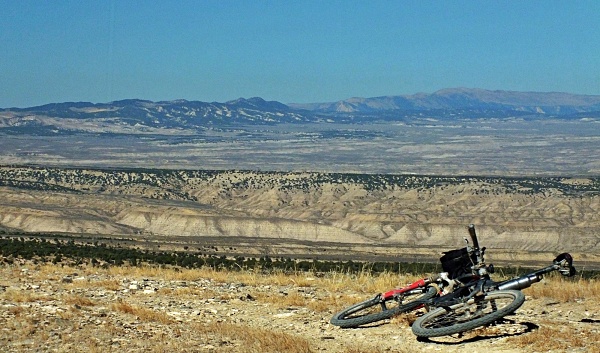
|
|
advertisement |
|
|
advertisement |