| |
| |
Blowout Pass
The eastern San Juan Mountains do
not reveal their size and splendor until you get
into them. From US160 between Del Norte and South
Fork they appear more like a shapeless forest in
the distance, topped by a few high rock outcrops.
Once you get into them their size becomes
apparent. Blowout Pass is a remote pass in this
area.
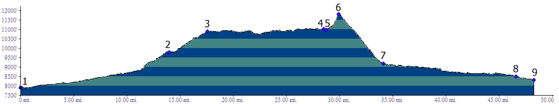
From South. The profile shows the most
obvious way to approach Blowout Pass, FR14 (Pinos
Creek Rd) leaving from US160 just west of Del
Norte. But there are many other options. The road
is initially paved and becomes heavily graveled
(as of June/10), before it crosses into the Rio
Grande National Forest. From North. (also described upwards) From
just north of La Jara Co371 heads west. It turns
into a dirt road that follows some of the northern
most headwaters of the Rio Grande River up Alamosa
Creek. Gradually the road actually starts to climb
into a plateau that can hardly be recognized as
such, from the distance. The profile starts at Terrace Reservoir, where the climbing becomes noticeable. Rolling terrain through a mixture of pleasant forested canyon and private ranches, also a nice free campground, leads to the collection of houses in the woods, named Jasper. Apparently this community has its roots as a mining town, but today it looks more like a collection of modern vacation houses with a special affinity for solar power.
The turnoff up Blowout Pass is marked with a very
small sign. In spite of this the road made me
wonder if I just was riding up some small communal
driveway in the woods. But sure enough - it
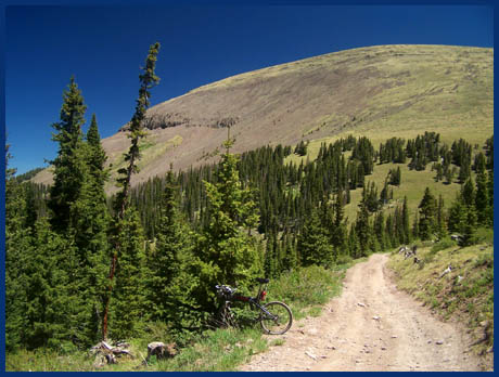
continued. The road climbs very steeply on a rough
rocky surface in the woods. I walked much of it.
This way I had enough energy left to at least ride
part of the last two miles, much of which have a
smoother surface, and are also not quite as steep.
That was my impression, but the elevation profile
seems to average it out. Finally the last few hundred feet of the climb
are above treeline. A trail up to the right to the
top of Bennett Peak (13203ft) looks like it would
give a very far reaching view. The most scenic way
to continue from here on a bicycle would be the TR700 Dry
Creek summit. But instead the profile makes
Blowout Pass the highest point and descends from
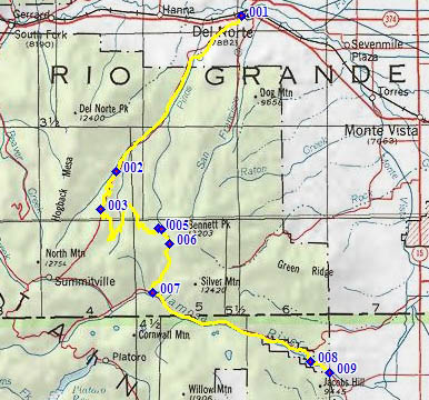
here. A Day on a tour PARTIALLY PAVED / UNPAVED (<Stunner Pass|Carnero Pass>) La
Jara > Co371 west > up FR250 along Alamosa
river > Blowout Pass > down FR330 > down
FR12 > Del Norte: 70 miles. (mech Odo:
m1.87.09.11). A Dayride with this point as intermediate
summit is on page: FR330
Greyback Mtn s(u) Historical Notes Today Blowout Pass seems like the absolutely most
cumbersome way to get from Summitville to del
Norte. Yet - in the late 1800s, the road was used
to move ore from the mining center to del Norte.
Later it was even used for freighting.
|
|
|
advertisement |
|
|
advertisement |