| |
| |
Alta Lakes s(u)
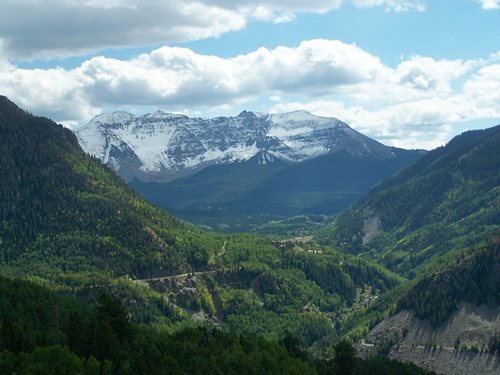
This high alpine lake area is a
well know scenic area near Telluride, that -for
now- still retains a primitive, undeveloped
character, even though it is quite heavily used
(Sept 2011). There are signs that the primitive
character situation may not last much longer in a
highly affluent and developed neighborhood like
Telluride.
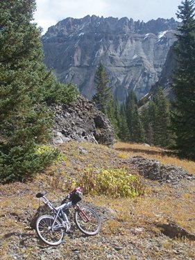
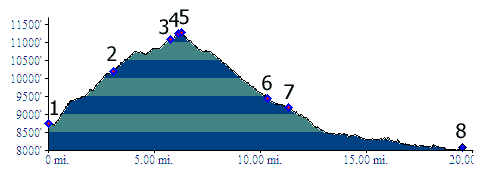
There are many ways to construct a loop ride with the first of the Alta Lakes at the highest point. However they all have to contain the same route over the summit: part of TR511 Alta Trail on one side, and the Alta Lakes dirt road on the other side. The route shown in the profile tries to maximize the approach height by adding lower sections.
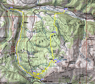
From North.There are many options for the
lower part of this approach, thanks to the many
trails and roads into and through the Telluride
Ski area. The profile shows the way that's easiest
to find. Leave the valley at the gas station, that
has the nicely sounding name "San Miguel" on the
map. In reality it's just another Shell station. Here are a few other options, which require a
little more looking around for the right way. The
first objective is to get from Telluride to the St
Sophie lift station in the ski area. You can catch
the lift from the western part of Telluride
village or from"Mountain Village", a misnomer if
there ever was one. What name would you give
to this place ? The easiest way to do this is to
ride up Co149 towards Lizard Head Pass and take a
left after a few hundred feet of climbing.
The second leg of this mission, should you decide
to accept it - is to find the Prospect Trail from
the gondola station. This single track leaves
between a maze of dirt roads, ski tracks and
maintenance trails, encirceling a few trees that
are allowed to remain standing in the area around
the ski lift station. A nice lady in a very small
kiosk, about the size of an out house, will be
happy to point you in the right direction. She was
hired to do things like that. This perfectly
smooth, nicely prepared single track trail
basically contours over to the more remote part of
the ski area, crossing ski runs periodically,
passing a lift station, the Ute Express, then
crossing a labeled streem, Prospect Creek. Past
this point the trail climbs a couple hundred feet,
crosses a beautifully partially cleared Boulder
field (I don't know if this is a ski run or
not), then skirts uphill on the edge of a very
wide ski run. Here signs saying "Prospect Loop"
start to make an appearance. After paralleling a
road in sight distance for a couple hundred yards
a sign to the left reads "Boomerang Trail".
Another option for this leg is to pick up the
Prospect Trail from the other end, leaving
somewhere in that place called Mountain Village.
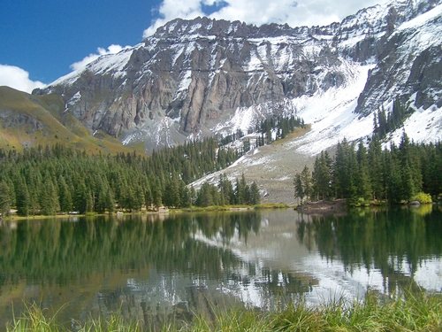
From South. (described downwards). After
encircling the lake and being badgered by ducks
for bread crumbs, looking at the reflection of the
sheer cliffs in the water, taking a few pictures
trying to avoid the jeeps and diesel trucks of the
other visitors, the road back down to the ghost
town is quick. Now it may be time to take a closer
look at these decaying structures. Is it ugly or
is it picturesque ? It is definitely history. The
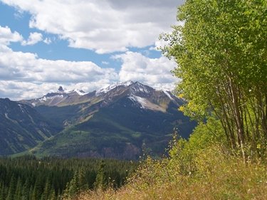
rest of the dirt road downhill has some of the
best views along the route, Mount Wilson next to
the diminutive but unmistakable Lizard Head Peak,
Sunshine Peak in the shadow foregrounding the road
cuts of Lizard Head Pass. The profile turns left,
going up Lizard Head Pass on Co149, but doing this
while still going downhill. The profile turns
right onto South Fork or Ilium Road (same road,
different name -unpaved) to join Co145 below
Telluride. An alternative for this road is to pick
up the Galloping Goose Trail, following an old
railroad grade. It does not reach quite as low as
the road.
History Cycling: An early
guide book from the 1980s (Bicycling the Back
Country, by William Stoehr, describes the out and
back ride on the dirt road from Co145. Today's
tourist brochure, available from the Visitor
Center at the entrance of Telluride, has the loop
route. Bicycle stores also sell a plastic encased
version of this map for 11 dollars. You can save a
grand total of 11 dollars by stopping by the
visitor center instead, what a grand savings ! Dayride with this point as highest summit:
|
 Approaches