| |
|
|
|
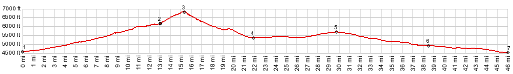
1.(4560ft,mile00.0)
START-END WEST: Center Street, Oakley
2.(6160ft,mile13.0)profile turns left onto City of
Rocks Rd
3.(6820ft,mile15.3)Elba Pass
4.(5350ft,mile21.8)profile turns left onto Elba Almo
Rd
5.(5700ft,mile29.6)Elba-Almo Divide
6.(4920ft,mile38.3)START-END EAST: jct Id77 -
Elba-Almo Rd
7.(4520ft,mile46.0)START-END EAST ALTERNATE: jct
Id81-Id30S Malta
|
|
![]()