| |
|
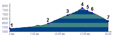
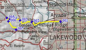
01.(5360ft,mile00) START-END NORTH ALT: jct: Clear Creek bike path - Kippling Ave.
02.(5930ft,mile08) START-END NORTH: beginning of Golden Gate Canyon Road, just north of Golden
03.(6920ft,mile12) Crawford Gulch Road diverts on right
04.(7750ft,mile15) Golden Gate Pass
05.(7430ft,mile16) START-END SOUTH: profile follows historic route down Guy Gulch on left, near low point of paved road
06.(7200ft,mile17) jct with trail on right, climbing to Centennial Cone Park
07.(6230ft,mile20) START-END SOUTH ALT: Guy Gulch terminates with jct in Clear Creek Canyon