| |
| |
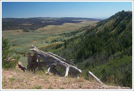
Muddy Mountain Road s(u) Muddy Mountain is a tree
lovers paradise in the sea of dessert around
Casper. It belongs the northern end of the
Laramie Mountains. Here this range does not
have the scenic low rocky peaks with billowing
rock outcrops, like further north around
Laramie Peak. Instead these are sweeping
plateaus with a thick, still healthy pine
forest on top. Unlike many of the other
forests, the pine beetle seems to have limited
reach here up to now (2015).
It seems like many things are called Muddy in east central Wyoming. There is an abundance of Muddy Creeks, even if it really does not rain very often.
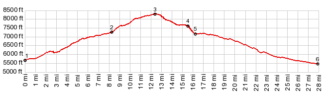
The two other options climb steeply. The one to
the left connects to paved Wy251 on
top of Casper Mountain. The profile takes
the only option left, on the right, a climb on a
wide gravel road heading west to Muddy Mountain
and its campground. The road climbs the plateau
in one sweeping turn. On the way a high meadow
with views in two opposing directions and a host
of semi dead trees and rock outcrops is the most
inspiring location on this ride. Looking down,
the plateau has a thin harder layer of caprock
at about half height, giving the table a
picturesque second rim. From here the road climbs only intermittently
and a few feet at a time. Entering the Muddy
Mountain area, there is an astonishing amount of
infrastructure, considering how remote this area
is: a developed campground, appropriately named
Lodgepole, hiking trails through the forest, a
plethora of educational tablets, a porch
constructed from wood to look out over the north
and its far reaching spaces.
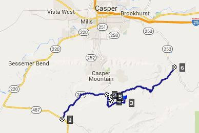
My map shows trails or roads going down the
east side of this mountain to make a connection
with Wy253 and eventually Casper. I check out
one of the trails. But it leads me in a loop
back up to Muddy Mountain. Along the way I
encounter a big truck parked next to a makeshift
tarp camp, surrounded with coolers, plastered
with Coors Light logos. It's a mystery how this
truck got here. One direction is a two track
trail, which is closed to motorized traffic, the
other direction is so deeply rutted you could
not drive down here. I check out one more of all the unsigned
turnoffs. It turns to sand and leads to many
more unsigned forks. But there is a nicely
developed road back down on the north side,
immediately before entering the Muddy Mountain
developed facilities. That is the route on the
profile, and the junction is also the highest
point. 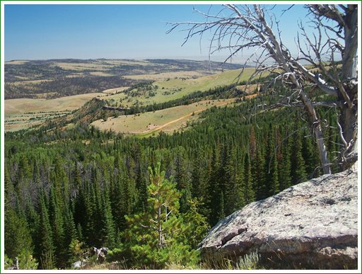
This track forks. One option allows connecting
back to the southern approach at half height.
But the profile takes a right through a gate and
connects to the "extremely cyclable ranching
road through public land, connecting to Wy253"
mentioned above. Most rides will turn left here
and head back up to the Circle Drive - Beaver
Creek(sh). But I continued the profile on this
side to the point where the road connects to
Wy253. Dayride with this point as highest summit: COMPLETELY UNPAVED ROADS AND TRAILS: ( < CR505
Casper Mtn Rd - Circle Drive(sh) | CR67
Slip Rd northern summit s(u) > |
 I have a short conversation with
a couple resting here with their two haute
couteur miniature dogs. The woman tells me how
much Casper has changed from 25 years ago, when
she moved away. We talk about the spacious. wide
streets of Rawlins. "Yes, some streets are so
wide they painted white lines on the sides, just
so that the bicycles have a extra space", her
husband adds. Yes - that really is a nice idea.
I have a short conversation with
a couple resting here with their two haute
couteur miniature dogs. The woman tells me how
much Casper has changed from 25 years ago, when
she moved away. We talk about the spacious. wide
streets of Rawlins. "Yes, some streets are so
wide they painted white lines on the sides, just
so that the bicycles have a extra space", her
husband adds. Yes - that really is a nice idea.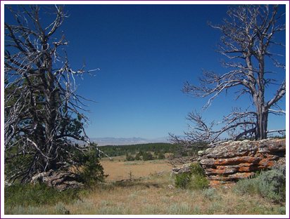
|
|
advertisement |
|
|
advertisement |