| |
| |
CR505 Casper Mountain Road
- Circle Drive s(u)
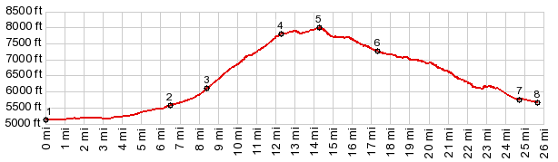
Casper Mountain makes a great out
and back paved climb. But the Non - Casper side is
paved to less than 300ft down from the summit. So
I am putting this with the unpaved climbs.
This plateau is a kind of retreat area for Casper, retreat from heat, dessert and the endless horizon - retreat into a dense forest, a ski area and camping with trees.
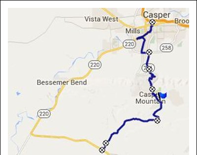
Approaches No matter which road you take in a northerly
direction, it climbs steadily. I think the best
way to get to the northern outskirts is just to
make use of the spacious residential streets in
this town. They are so wide, they resemble mormon
towns, which are designed to biblical proportions. Somehow you arrive at Wyoming Drive or Outer
Drive, same road, different names (point 2), and
Mount Casper looms above, rather shapelessly. It
doesn't look like much from down here. It's
definitely not a wall. It is more of a lump. It
will seem much bigger from the top. Both Wy251 and Wy252 climb towards it. The
profile uses the more direct Wy251. The last
houses quickly thin out. This is one of the few
occasions in Wyoming, where you can see a road far
ahead - but it's not heading for the horizon in
straight line. Instead it cuts across the loaf
ahead in a straight traverse. It takes a while to get there. The road has a
uniform slope. a good shoulder, and even a "share
the road with bicycles" road sign, though I didn't
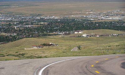
see another bicycle. Before the road heads back into the interior of
the narrow plateau, there is a gigantic parking
lot, from which to survey the incredible, vast
treeless spaces below. And there is also the wide
North Platte River, meandering through the
dessert, where the ride started. With the road now
safely in the trees, a home appears next to the
road. The sign reads "Shangrila" (spelled that
way). It consists of a double garage at street
level and the living level below that, facing the
other way, safely out of the wind. This profile stays left at the next junction. A
right goes to the Hogadon Ski area. You drive to
the top of this one, then after the ski run, let
the lift carry you back up to the car. This
reduces the theoretical maximum number of ski runs
you can get into a day by one, compared with a ski
area where you drive to the bottom and a equal
lift closing time. A note: From the map it looks
like there is a primitive road down the south side
of the mountain, so that this could also be made
into a summit point. But this profile, as already said, stays left at
the previous junction. This option climbs a little
more, less than 300 ft and then traverses the
forested top between parks, campgrounds and
retreats. This could be the middle of Indiana or
Minnesota, if you forget the climb. Meanwhile the
road designation has changed from Wy251 Casper Mtn
Road to CR505 Circle Drive. From South. (described
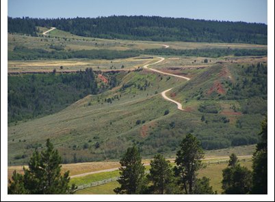
downwards) But the Wyoming wide spaces return
quickie. After only descending a little less than
300ft, the surrounding forest disappears - so does
the pavement - an the wind returns just as
quickly. At the next major superwide rocky dirt
road boulevard intersection, there are options for
climbing east up Mud Mountain,
or heading east for Wy253. But this profile
descends further on CR505. This road stays on top of a small grassy ridge,
which itself is in the valley of Big Red Creek.
(Many of the names here seem to include "Big" and
"Mud"). The view is terrific, a ribbed red cliff
leading the eye to the horizon and the distant,
from here small lumps of the Pedro Range. The road
passes a Cheney Ranch and makes one more small
climb before descending through state land on a
smooth road to Wy487, or alternatively, the
unpaved but smooth Coal Mountain Road.
Dayride with this point as highest summit: PARTIALLY PAVED / UNPAVED: ( < CR409
Pathfinder Rd s(u) | Muddy Mtn Rd
s(u) > ) |

|
|
advertisement |
|
|
advertisement |