| |
| |
FR10 Hunt Mountain Road
s(u)
Hunt Mountain Road connects the
two northern most, paved passes in the Bighorn
Mountains, Granite
Pass and Baldy
Pass. In this area the Bighorn Mountains
really are more of a plateau than a mountain
range. There are two interesting aspects to this
road: first, the out and back possibilities to the
rim of Shell Canyon, and second the windswept
treeless desolation of the top section.
The turnoff to FR10 is about 70ft below the
summit of Granite
Pass on the east side. From here a few
curves with the radius the size of a football
field, the road gradually climbs into ever more
treeless expanses. At what seems like a first
summit FR217 on the left climbs a little higher
and then descends ~400ft to the rim of Shell
Canyon. This trail is much rougher than FR10 and
the shortest option to get to the canyon rim. The
view is worth the trip. But this is the only
optional sidetrip to the rim that I tried. This
sidetrip is not included in the elevation profile,
but I did put a picture in the slide show. After the canyon views this FR10 seems a little
anticlimactic with its rolling hills stretching to
infinity, the only real landmark the high peaks in
the Cloud Peak Wilderness area, fading into
a flat horizon. However it gets better. Soon a
long line of sculpted looking rocks appear as a
complete contrast to the vast flowing green
surfaces that the road has been crossing. These
rocks very close to FR10, but FR808 leads through
them for a closer look and an ideal lunch spot.
The road is much closer to the edge of the plateau
now, and a straight cliff of Shell Canyon can be
seen where the table falls off into the basin.
From North. A short
curvy descend between high grassy cones intersects
with US14alt, again east of its summit, about
200ft below it. The profile goes down the east
side. This is fast straight ride with a few mild
bends but no curves. Cliffs poke into the
landscape between trees. The road becomes a mild
slope in the high shallow grassy bowl of the
Tongue River. The profile continues to Burgess
Jct, where it meets up with the southern approach.
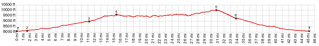
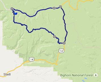
PARTIALLY PAVED / UNPAVED ( < Cutler Hill s(u) | FR17 Paintrock Rd s(u) > ) FR10 Hunt Mountain Road s(u) , additional out and back : near jct FR652 - US14 > US14 west > FR10 Hunt Mtn Rd north <> out and back to end of FR217 > FR10 north > FR10 Hunt Mountain Rd s(u) > US14alt east > Burgess Jct > US14 west > back to starting point: 55.8miles with 4230ft of climbing in 5:52hrs (Garmin etrex30 m5:15.8.9). Notes: a remarkably cool ride for the middle of August. I never took my jacket off. 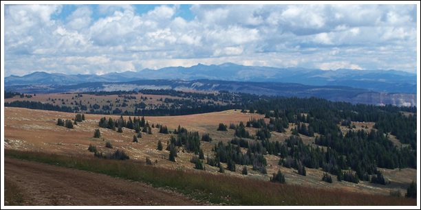 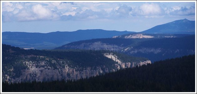 |
 Back on FR10 the road just rolls
along and I check my altimeter with every bump if
a new high point has been reached. But this
doesn't happen until almost the end of Hunt Road,
and then it is obvious. The sweeping quality of
the landscape reaches new heights, and it's hard
to believe that this high elevation can appear so
flat or barely rounded. Not far away the
pavement of the
Back on FR10 the road just rolls
along and I check my altimeter with every bump if
a new high point has been reached. But this
doesn't happen until almost the end of Hunt Road,
and then it is obvious. The sweeping quality of
the landscape reaches new heights, and it's hard
to believe that this high elevation can appear so
flat or barely rounded. Not far away the
pavement of the |
|
advertisement |
|
|
advertisement |