| |
|
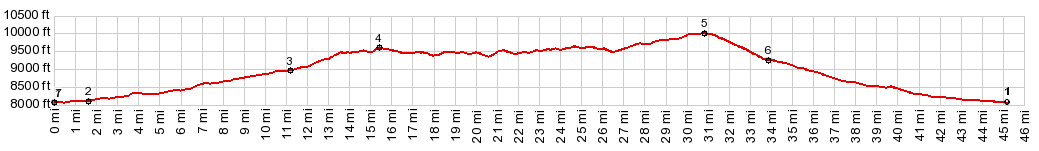
1.(mile00.0,8070ft) START-END EAST-1: low point on US14 at jct with FR159
2.(mile01.6,8110ft)At Burgess Jct the profile turns right onto US16
3.(mile11.3,8970ft)route turns right onto FR10, just before Granite Pass
4.(mile15.4,9600ft)turnoff to FR217 on left. This leads to an overlook over Shell Canyon
5.(mile30.8,10020ft)TOP: highest point on FR10 Hunt Mountain Road
6.(mile3.8,9260ft)profile turns right on US14 from Granite Pass
7.(mile45.2,8070ft)START-END EAST-2: low point on US14, same as point1
|