| |
| |
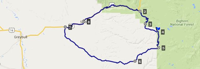
FR17 Paintrock Road s(u)
FR17 is a kind of main back road
to access many remote wilderness points in the
Bighorn Mountains. It is also a high traverse
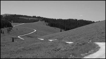
below the gentle flowing ridge line, negotiating
all the hills and dales in between in endless
curves. But the most unusual part of this summit
as profiled, is the lower section through the
dessert of Red Gulch. While signs use the name
Paintrock Rd. some maps also use the name "Battle
Creek Rd" for the upper northern approach.
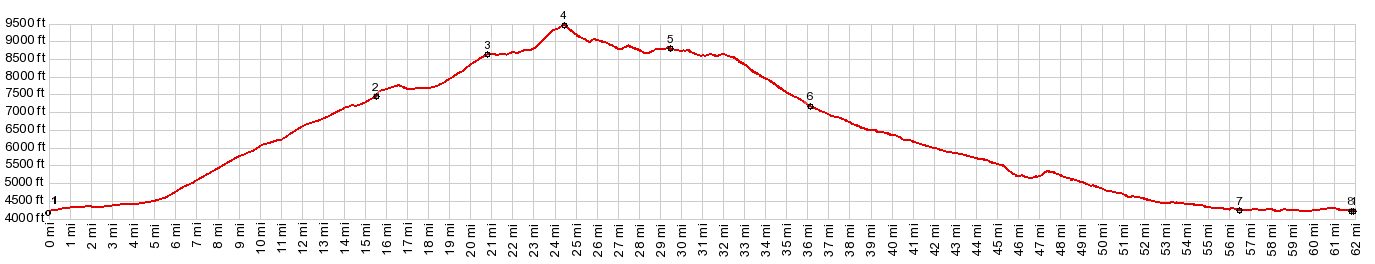
Approaches After first traversing above this valley the road
drops to the busy bottom with campgrounds and a
national forest ranger station and other
maintenance buildings. Here the road makes an
abrupt right turn and climbs through dense forest
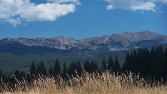
the ridge to the west. On top is a nice open view
of the flat bread loaf like crest of the Bighorn
Mountains, and an official looking pass sign,
saying "Snowshoe Pass". But the sign could just as
well have been put up by the owner of the nearby
real estate investment, in order to cutsify his
property. In any case the road keeps on climbing.
It finally reaches a tough climb on a straight
road, over a matrix of embedded rock, between a
herd of bewildered cows. The road levels out
gradually towards the top, enters a clearing and
presents a magnificent view at the summit. The
steep climb visible across is not part of FR17. From South. (described
downwards) Instead this route branches off at a
junction below not visible from the summit, and
follows a roller coaster, curving in three
dimensions at once through the hills, alternating
between dense forest and open range land. The profile finally turns off FR17 in order to
get back to the valley at the signed junction with
FR328. The feature the road is named after,
Paintrock, is further north on FR17. The change in
the character of the land on the profiled route
ahead is about as complete as one can imagine.
First a straight line of a road leads into open
range land under state wildlife area management.
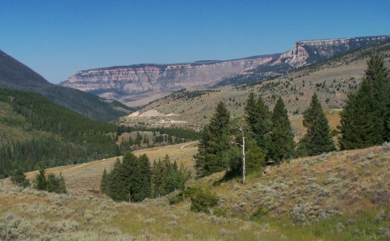
The distant cliffs of Shell Canyon form a long
straight line behind the sage. They contrast in
form and color with the billowing white clouds
against the blue sky. After this not very steep rocky descent (no
reason to worry about having to replace those
expensive and fickle disk brake pads) the road
finally reaches a desolate signed intersection
with the Red Gulch/Alkali Scenic Byway. In order
to get back close to the starting point, the
profile takes the Red Gulch option on the right. But Red Gulch is still some distance away. But
gradually after many miles of riding, the view
verifies a gradual change of direction to the
north, with the cliffs of the Bighorn Mountains in
the Shell area appearing ever more spectacular.
There are short sandy sections, which make for a
few tense moments going downhill, and would
probably be a royal pain in the ... going uphill.
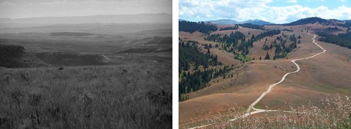
At one point after a particularly interesting
view, with totally red buttes foregrounding the
pastel cliffs below the billowing clouds, the road
makes a steep descend in order to climb a steep
gap between badland shales. There is strong
temptation to maximize the speed through the dip
below. Problem is, the dip is deep sand. I just
barely managed to avoid a bad wipe out at full
speed. But maybe the sand would have been safe
enough to cushion the blow. It certainly seems
deep enough. After the danger of the sand comes the
humiliation of deep gravel on the climb to the
dip. But it is only a matter of minutes and in the
scheme of the whole loop, not even worth
mentioning. The road ends with the scenic climax
at the bottom approach direction Shell. The
dessert buttes in the foreground now have strips
of various colors that underline the linear nature
of this landscape. Road conditions are variable
here, depending on what the road grader is doing
currently. If there is time left there are also
some dinosaur tracks to examine. The profile as
well as the gradual intermittent downhill continue
on paved US14 all the way into Shell, where the
Road crosses Shell Creek. Dayride with this summit as highest point: PARTIALLY PAVED / UNPAVED ( < FR10
Hunt Mountain Rd s(u) | Baldy Pass >
) Slideshow of Red Dessert part
of this ride on lower South Side |
|
|
advertisement |
|
|
advertisement |