| |
| |
Cutler Hill s(u) Cutler Hill is the eastern summit
on US14 over Granite
Pass. About a 700ft drop separates the two.
But this point can also be approached without
going over Granite Pass, using some of the unpaved
roads in the area.
This road over the Bignhorn Mountains seems to have a little more traffic than the parallel alternative Powder River Pass, since it seems to be used more by Yellowstone bound tourists. Still - most times traffic is light. There is a good shoulder, but near the summit it sometimes has gravel on it from the last resurfacing operation. - No rumble strips.
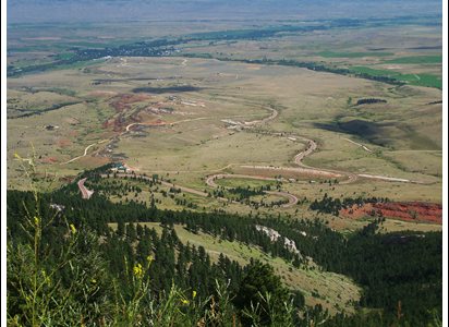
Approaches From here on the road climbs continuously, not
very steeply, but unusual for a Bighorn climb - it
never goes down until it reaches the summit of
Cutler Hill. First this happens in wide radius
turns, as if the road seems to encourage momentum
to get up the hill. Looking ahead you can always
make out the next traverse above. This climb
traverses back and forth along the initial
escarpment. The land below is a wavy, treeless,
expanse of badlands and rangeland, except for
Dayton. It is one oasis of trees lining the Tongue
River. As the road gains elevation several turnouts
allow spotting bits and pieces of the road below.
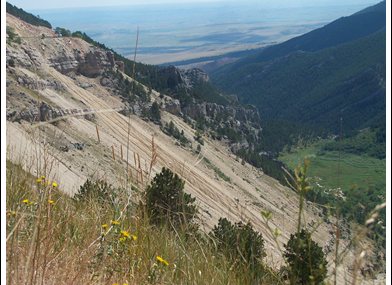
When the road finally turns into the Bighorns, two
more industrial sized parking lots point out
monumental pieces of rock that have tumbled into
the valley by being undercut. Even the de Lome
atlas labels this with the touristic phrase
"fallen city" (picture lower right). I wonder if
this came about because Yellowstone bound tourists
were looking for well labeled attractions. Another turnout to the right shows off a great
view of the canyon of the Tonque River. This is
easily missed, because you have to go all the way
to the end of this particular gigantic parking lot
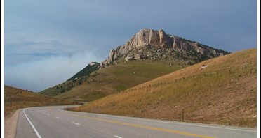
at the foot of a upturned lawyer of rock. Past this the road enters forest and climbs
slowly and intermittently to this summit point.
There is a sign complete with elevation on top.
The view is limited From West. A 700ft
drop leads past a small lake, which is another
"prescribed" photo stop for the official
Yellowstone bound tourist. - See the road sign
with the little camera on it ? From there the road
starts climbing again a bit towards Burgess Jct. Dayride with this point as highest summit: PARTIALLY PAVED / UNPAVED / INDISTINCT TRAIL: ( <
Powder River Pass Rd eastern summit s(u) | FR10 Hunt
Mountain Rd s(u) > ) |
|
|
advertisement |
|
|
advertisement |