Battle Lake Pass
Battle Lake Pass, also
called Battle Pass is a surprisingly high
crossing point on the Continental Divide in
the Sierra Madre of Wyoming. There are lower
forestry road crossings on the north side of
the pass. This gentle forested range is a
continuation of the Park Range in Colorado,
and a ride here consists of peaceful
solitude in the trees, similar to what one
would also get from Gore
Pass in Colorado for example.

|
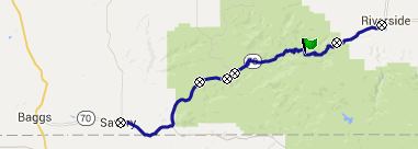
1.(mile00.0,6470ft)START-END
WEST: low point on US70, where it
crosses Savery Creek, between Savery
and Slater
2.(mile15.5,8080ft)Stock Drive Road
crosses US70
3.(mile19.4,8430ft)turnoff to overlook
point on south side of road
4.(mile21.0,8300ft)turnoff to Sage
Creek Rd on left
5.(mile33.1,9955ft)TOP: Battle Lake
Pass
6.(mile44.1,7510ft)turnoff to FR443 on
left
7.(mile45.6,7280ft)START-END EAST:
Encampment |
 Approaches Approaches
From West. Heading east
from Baggs, the next sign of civilization is
the sign announcing Slater. - Hard to say
where the spiritual center of Slater lies.
First I wanted to say, right at the sign that
says "population 25". The sign looks faded
enough, that recent births and deaths may not
be be reflected in this running total. But on
second thought, I think it lies at the
excellent pioneer museum, a block or two to
the north. I think that is the real center of
town. From there the road still descends into
Savery, and this is finally where the profile
starts. Slater and Savery are easy to get
mixed up. Savery has the post office. Slater
has the sign. Neither one has food of any kind
for sale.
 Wy 70 climbs gently
toward a trapezoidal mesa, blocking the way. I
first thougth this location fit the
description of Battle Mountain, after which
the pass is named. But the real Battle
Mountain is further north along the unpaved Columbine
Pass road, which branches to the right
in this area.The lake, also named after the
same battle, is actually closer to the top. Wy 70 climbs gently
toward a trapezoidal mesa, blocking the way. I
first thougth this location fit the
description of Battle Mountain, after which
the pass is named. But the real Battle
Mountain is further north along the unpaved Columbine
Pass road, which branches to the right
in this area.The lake, also named after the
same battle, is actually closer to the top.
Wy70 continues to climb a small curving
incline, and given the right light conditions,
lets you peek over a line of aspen trees onto
the ridge of mountains leading up to Hahn's
Peak. Grassy, angular Wyoming plateaus are the
foreground to what is currently the pine
beetle kingdom around Hahn's Peak.
The road enters the Medicine Bow National
Forest, and the forest itself too. A sign
explaining the crossing of the Savery Stock
Driveway is easily missed. In the 1800s, sheep
herders used to cross here between summer
pastures in the Park Range, stretching up into
Colorado, and Wyoming's Red Dessert. Still
today there are numerous herding carts on the
unpaved back roads, that strongly resemble the
rounded metal roof carts from that period. Now
and then you also still encounter a herd of
sheep.
After a mildly sloping ride through dense
forest, a short detour to the right leads to
the best overlook on this pass road. It is
another version of the same panorama, visible
from below. But now Battle Mountain forms the
extreme right of the 200 degree field of
vision, while on the other side the Mount
Zirkel wilderness looks like nothing more than
a distant lip of snow around a row of small
teeth.
Sofar the entire approach has been part of the
Great Divide Bicycle Touring route. Just after
the viewpoint, that route turns left onto
FR801 to descend on the Deep Creek
Road, while Wy70 keeps climbing gently
after this dip in the road.
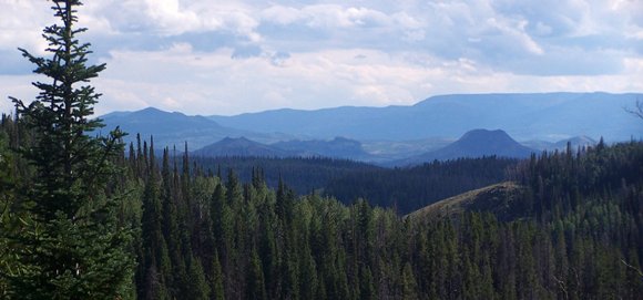
Continuing to Battle Pass there is still lots
of climbing to be done. The new road bed uses
only large radius curves and slopes of 7
percent or less. This saves the drivers the
indignity of shifting. I don't know what good
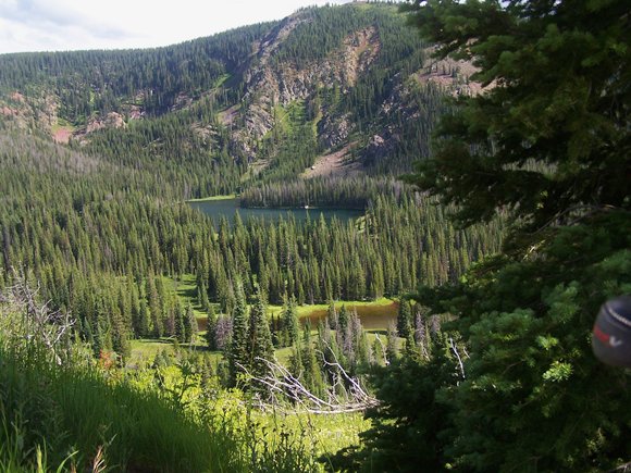
it does for cyclists. Eventually, after many
swings through the forest a view point to
Battle Lake appears on the right. This is an
unusually rugged location for this rather
gentle mountain range. From here the top is
also in sight. It appears as a treeless meadow
in a gentle saddle above.
At the top is a pass sign, calling this
location Battle Pass rather than Battle Lake
Pass, as Marshall Sprague does in his
definitive history of Rocky Mountain Passes. A
major attraction of the large parking lot at
the top is that it seems to be always
deserted, and it has a decent view also. The
highest peak in this range can be seen on the
right, Bridger Peak with barely a rock outcrop
at the top.
From East. (also described upwards).
Leaving Encampment, the road heads for the
trees. The junction with FR542, which I used
to make a loop around Bridger Peak is not
signed. But it is located at the start of a
chainup area at about 8800ft. Past that the
road breaks out of the trees periodically. The
tree skeletons left by the pine beetle make a
stark foreground in the pictures of this area.
Dayrides with this point as
highest summit:
PARTIALLY PAVED / UNPAVED:
Battle Lake Pass x2:
Encampment <> Battle Lake Pass <>
turnaround point at National Forest Boundary
on west side: mechanical odometer (m1:91.7.13)
Notes: this was before the current road bed
and included a short section of unpaved road
that is now paved.
( < Wy70 Battle
Lake Pass Rd(sh) | BLM3328
Miller Creek Road south(sh) > )
Battle Lake Pass , FR543
South Spring Creek s(u) , FR830
Deep Jack Th s(u) , Wy70
Battle Lake Pass Rd - FR801 Deep Creek Rd
: jct FR807 Savery Stock Driveway - Wy70
> Wy70 east > Wy70 Battle Lake Pass Rd -
FR801 Deep Creek Rd > FR830 Deep Jack Th
s(u) > FR452 east > FR452(shp) >
FR543 South Spring Creek s(u) > FR543 north
> Wy70 west > Battle Lake Pass > back
to starting point with short additional out
and back down Wy70 for an extra 100ft of
elevation gain: 75.1miles with 6940ft of
climbing in 7:17hrs (Garmin etrex30
M5:15.7.18)
Battle Lake
History
The Fur Trapper Period: This
battle happened in 1841, between a group of
trappers led by Henry Fraeb and a group of
Sioux, Cheyenne and Arapahoe. A sign on the
eastern overlook (not the summit overlook)
reminds of this event and points out Battle
Mountain, where this all happened. The route
profiled on the Columbine
Pass page actually comes much closer to
Battle Mountain itself.
A mining town named "Battle" was
founded in 1898. It reached a population of
250 and included a newspaper, two hotels, a
general store and a land office.
|