| |
| |
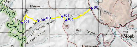
Ut313 - Spring Canyon Road
(sh)
Ut313, the road to Island in the
Sky, has a cleverly disguised turnoff, that leads
to several overlooks and access points of the
Green River. The sign at this junction simply
reads "Big Mesa Group Camping Area". Following it
takes some tenacity, because the canyons are still
some distance away, and also - you have no idea
that you are near the edge of the canyon of the
Green River, until you are actually at the very
edge.
When riding to Spring Canyon,
this cleverly disguised turnoff also happens to be
the highest point along the route. Ut313 just
keeps on climbing past this point to more visited
overlooks. Consequently this summit point is
a shoulder summit to the Ut313 Island in
the sky s(u)
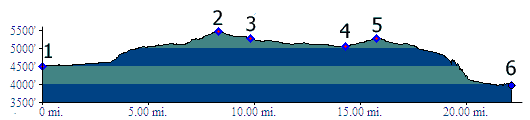
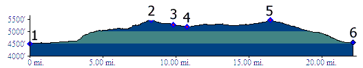
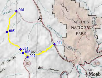
From East. The profile begins where Ut313 turns off US191. This lower part of the road is also called Seven Mile Canyon. It passes two square buttes on the right (one is Merrimac Butte), and pronto - you are at the top already. It's all downhill from here, in a netto sort of way.
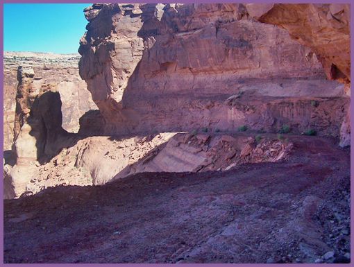
From West. (described downwards) A long fast ride over a good, straight dirt road, with periodically occurring crossings of where the road may be washed out, leads across the high, rolling dessert. An intermediate summit point (point 5) has two important, unlabeled turnoffs. The left goes to a southern overlook on the Green: Deadman Point. The right is labeled SS road and connects with other Green access points. The route ahead descends slightly, but as already mentioned there is no evidence that a canyon intersects the far view to the horizon and the Henry Mountains. The drop off appears in front of you, about 15 seconds before you find yourself on a shelf road, heading for a gap between a cliff on one side an a rock monument on the other. The road is still level on this short shelf section, but that soon changes. A single switchback gets the trail down to the bottom of Spring Canyon, and follows it to the Green. Unlike the geologically more complex descends closer to Moab, here the sheer ciffs over the Green are uniform Wingate formation with Entrada caprock. Actually the second nicest part of the ride starts here, even if it is not included in the profile. Old mining roads follow the Green both up and downstream as far as the next side canyon.
But you don't have to descend to Spring Canyon Bottom from the top of this shoulder summit. One can go right at point 3 and connect over another nearly equally high point towards the south, even if this bypasses all of the really scenically most interesting areas. It was my first ride in this area, and I still consider it a good training ride. In most other places I also felt lucky to see this scenery. But things are relative, and we are after all in the Moab area.
From North. (described downwards) The
profile turns off to the right onto Dubinky Well
Road at point 3. A confusing sign at this map
information turnoff gives the impression that the
route to Spring Creek Bottom also stays right
here. It does not, it stays left. As the road
makes a small descend on the plateau and then
climbs again, it can deliver quite nice views of
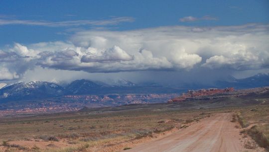
Merimac Butte foregrounding whatever weather and
cloud happenings are going on in the La Sal
Mountains. The climb to the top of Dubinky Well
Road (rd137) feels higher than the Ut313 turnoff,
but the topographic map says that it is lower.
This road tops out at a rock outcrop area and has
a short steep section before this intermediate
top. The descend down the other side is on an
elaborately engineered dirt road, that can
surprise with a few short sandy stretches. The
view shed is now to the north and west, taking in
the Book Cliffs and the San Rafael Swell. It
imparts a much more desolate feeling than the
sheer red canyons on the other side of this
shoulder summit. Finally a telephone line appears
in the low distance. That's the intersection with
the Blue Hills Road, and also the end of the
profile. Even though the Blue Hill Road visually
feels like it is descending to US191, it actually
climbs, then descends, with almost no overall loss
of elevation. History Cycling: An early guide book included a description of the western approach as part of a loop. The critical connecting link in this loop is a portage back up to Spring Creek Point. "Above and Beyond Slickrock" by Todd Campbell was published in 1991.
Dayrides PARTIALLY PAVED / UNPAVED Ut313 - Spring Canyon Rd(sh): Willow Spring Road (north of Moab, off US191) > US191 south > up Ut313 > Ut313 - Spring Canyon(sh) <> out and back on Spring Canyon Road and a spur road to turnaround before reaching Colorado River >> Dubinky Well Road (rd138) north > Blue Hill Road (rd137) east > US191 south > Willow Spring Road back to starting point: 63.5miles with 3070 ft of climbing in 5:07hours (VDO MC1.0 m3.11.10.7). Ut313 - Spring Canyon Rd(sh) x2:
out and back ride: Willow Spring Road (north
of Moab, off US191) <> US191 south <>
up Ut313 <> Ut313 - Spring Canyon(sh)
<> Spring Canyon Bottom <>
upstream/north along the Green River <>
turnaround point a short distance above Joe's
Mine, plus a few short spurs: 71.8miles with
3880ft of climbing in 6:42hours (VDO MC1.0
m3.11.10.9).
back to cycling Utah's summits and passes |
 Approaches
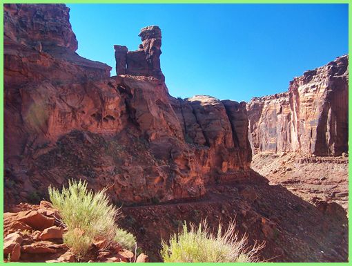
 From East. same as
above
From East. same as
above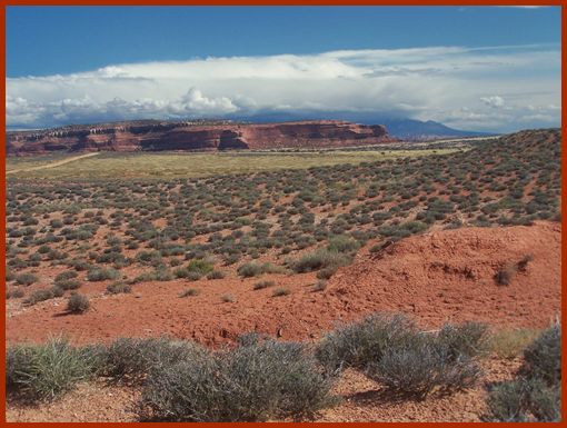
|
|
advertisement |
|
|
advertisement |