| |
|
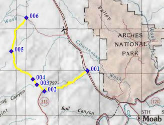
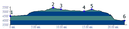
1.(4500ft,mile00) START-END EAST: -p1 in first profile- jct Ut313 to Island in the Sky area of Canyonlands Park - US191, north of Moab
2.(5490ft,mile09) -p2 in first profile- TOP: turnoff from Ut313 onto dirt road on right, Spring Canyon Road
3.(5280ft,mile10) -p3 in first profile- profile turns right onto Dubinky Well Road
4.(5200ft,mile11) intermediate bottom, at turnoff to Jug Rock Flat on left
5.(5469ft,mile17) intermediate top on Debinky Well Road
6.(4550ft,mile22) START-END NORTH: jct Dubinky Well Rd - Blue Hills Road
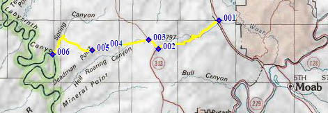
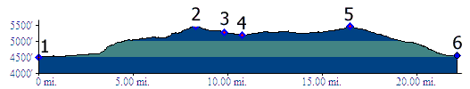
1.(4500ft,mile00) START-END EAST: jct Ut313 to Island in the Sky area of Canyonlands Park - US191, north of Moab
2.(5490ft,mile09) TOP: turnoff from Ut313 onto dirt road on right, Spring Canyon Road
3.(5280ft,mile10) profile stays left on Spring Canyon Road
4.(5050ft,mile15) intermediate low point
5.(5390ft,mile16) intermediate high point at junction: right connects to SS road, left goes to Deadman Point
6.(3980ft,mile22) START-END WEST: Spring Canyon Bottom