| |
| |
Kokopelli's Trail
summit(u):m114
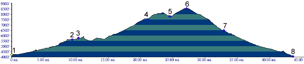
Mileage point 114, as referenced by the Copmoba brochure of the trail ( revision 3, 1996) is the highest point on the trail. Floating in lofty heights above red cliffs and below snow covered peaks, it is much less rocky than the previous lower summit at mile 88. Like the m88 summit(u) it can be cycled in a day loop, combining the Kokopelli's Trail with a descent down Castleton Valley. This is the route shown in the profile. All junctions on the Kokopelli Trail itself are very well signed.
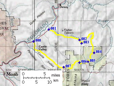
From East. The Onion Creek road connects
the Kokopelli Trail in Fisher Valley with Ut128.
Onion Creek road is also described in a downward
direction for the m88 summit(u). But a route like
this deserves to be described more than once. So
the least I can do is describe it again in an
upward direction. Early morning May sun bakes the red cliffs into a
shimmer. Once in the narrows of Onion Creek, dark
shadows from overhanging cliffs plunge the rider
into momentary darkness until the eyes adjust ,
exclamation marks in the form of ocher rocks
above. A second later blinding sunlight returns.
The 16 to 20 stream crossings seem to go by faster
than during the descent. This is due to decreased
stream flow in the still comparatively cool
morning.
With further climbing the ride turns into a
forested high plateau ramble in cool air under a
green, perpetually moving canopy, cows mistaking
my black monoframe Klein for a relative of theirs,
if I interpret their mooing correctly. Even though
this is mountain biking capital country the only
vehicle I encounter is a road grader - yes a road
grader. But the end of May is a relatively
uncommon time to do this ride due to the heat.
Opposite to what one might expect, the higher you
get the more elaborately engineered and maintained
the road actually becomes. Junctions with the
Polar Mesa and Gateway- Moab road ( Paradox Trail
) are signed. The La Sals Mountains, earlier
always the white outlined triangles behind the red
walls that together take on the shape of a big red
house from the distance, now seem reachable - with
just a little more effort. Past the junction with the Moab-Gateway road, the
rider now travels on a smooth surface, on which
good time can be made. The last climb to the
summit traverses a bread loaf shaped slope in open
forest between extensive views of Castleton Valley
and the towering La Sals. From West. The approach is described in a
downward direction. Surprise - Immediately after
the highest point the road turns paved, and the
descent into red hot valley heat between red
vertical cliffs is as fast as with a motorized
vehicle. One short, but steep uphill at the bottom
of this valley is the last remaining opportunity
for physical exercise that is left before the
route joins Ut128.
Dayride. A dayride combining the two
described approaches, completing the loop with
Ut128 through Professor Valley measured 50 miles
with 6250 feet of climbing in 5.4 hours
(m3:06.05.23).
back to
cycling Utah's summits and passes |
 Approaches


|
|
advertisement |
|
|
advertisement |