| |
|
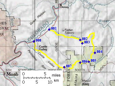
01.(4210ft,mile00) START-END EAST: junction Onion Creek rd and paved Ut128
02.(5630ft,mile10) junction with Kokopelli Trail, route continues on right
03.(5780ft,mile11) route turns to left, away from Fisher Valley Ranch
04.(7540ft,mile22) Kokopelli Trail turns left onto good dirt road
05.(7810ft,mile25) low point between summits
06.(8560ft,mile28) TOP: summit(u):m114
07.(6490ft,mile33) Kokopelli Trail continues onto paved La Sal Loop road on left, while profile continues down into Castle Valley
08.(4060ft,mile44) START-END WEST junction Ut128 and road to Castleton