| |
| |
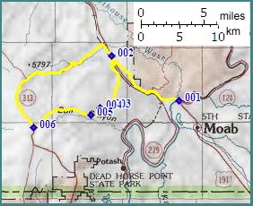
Ut313 - Gemini Bridges
Road(sh)
 It is
hard to believe that as late as 1961, hardly
anybody knew of the existence of the natural
bridges along this route. The fact, that now just
about everybody does, hinges on a rockhound named
Lin Ottinger, who was tipped off by a local. Then
it took a decade for him to find them again a
second time. Things have changed - there are still
arches to be discovered and named in the remote
canyons of Utah, but Gemini Bridges are not among
them. It is
hard to believe that as late as 1961, hardly
anybody knew of the existence of the natural
bridges along this route. The fact, that now just
about everybody does, hinges on a rockhound named
Lin Ottinger, who was tipped off by a local. Then
it took a decade for him to find them again a
second time. Things have changed - there are still
arches to be discovered and named in the remote
canyons of Utah, but Gemini Bridges are not among
them.As Todd Campell already noted in his 1991 guide book "now it isn't uncommon to hear of people hackysacking on them, or wheelying across them. Natural selection has its own special way of dealing with folks so inclined". In order to achieve this kind of popularity, a rockhound cannot bear sole responsibility. You need more. Somebody has to profit from all this beauty for things to really start happening, This is where all the able, energetic Moab merchants come in. They help feed hungry cyclists, sell gasoline canisters to motorcyclists, house them if the feel so inclined and even rent portable toilets to the campers. And yet, something is different about this town, different from so many other towns on the edges of National Parks. I think it is this: there are no mini golf courses, pony rides or christmas ornament stores in Moab (or at least I didn't see any). There are just plain fewer tourist trap businesses in general. Instead the town attracts business generated through organized marathon events like Outerbike or the 24 hours of Moab, and also organized bike tours over the La Sal Loop Road s(u). And then there are the music festivals ...
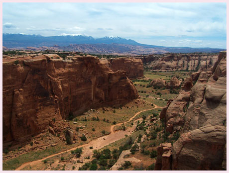
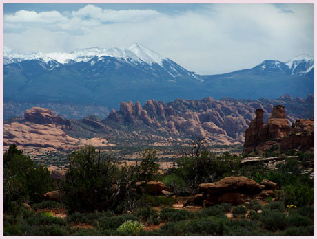
Approaches From East. Part of the fun of riding this route from Moab is the excellent biketrail, utilizing an abandoned roadbed between Arches National Park and the Gemini Bridges trailhead - and not paying the parking fee at the private ATV staging area at the trailhead. Past the trailhead the route is now well signed with "Gemini Bridges" sings, and after that Ut313 signs. There are several additional alternate loops and junctions along the way. Many options dead end below the cliffs of the Wingate formation. The area appears to be totally closed to camping these days (Oct/11). As a result I didn't see any people at all on the road during my last visit, except for a group of five Bridge frolickers. This is much less than during previous years. Continuing from the trailhead, the dirt road parallels the highway for a short distance back to Moab, then climbs the first lip to deliver the picture perfect view of Moab between power lines and rocks shaped like a million times magnified tire track. Here the route enters Little Canyon. If you were to guess that rain falling here, should end up back down near US191 (let's assume it rains really hard, and the water does not just absorb into the ground), you would a reasonable person, but taking a closer look will show otherwise. The water drains towards the Colorado on the west side. Little Canyon hangs above US191, put there by the Moab fault, where displacement has taken place due to massive underlying salt layers. The road rolls down the upper part of Little Canyon. But then rather than following the canyon down to the Colorado River, the route turns west and follows what has been named "the Boulevard". There is no shopping here, but there are plenty of turnoffs to spend much possible time exploring. After traversing lone standing rock outcrops, grouped into garden like formations by the big gardener in the sky - or geology, a steep sandy turn to the right at a junction signals the exit from "the Boulevard". These slickrock outcrops in this area are somewhat of an oddity. This too can be the Wingate formation, the ubiquitous cliff-forming orange, burnt sandstone, that makes up so much of the cliffs around here. Only here, the caprock - the Entrada formation, is not present and it erodes into fins and domes. A short series of climbs traverses sand mixed with rock outcrops to the Gemini Bridges viewing area. Here it is not uncommon to wander around with clickety clackety cleats searching for - where the heck is this arch anyway - when discovering that your are standing on top of it. Another thing you are standing on is the Entrada formation - welcome back. The bridges formed right at the edge of the reappearing contact point between the Entrada and Wingate. Natural bridges are formed when a river meander, deeply incised into a canyon, becomes a cutoff meander. Arches are formed by all other erosional forces of wind and water, including seepage. Now that we have that out of the way ... It is not really clear that Gemini Bridges are natural bridges. They could be "just" regular old arches. The road continues to the right of the
arch/bridge viewing area, then immediately turning
left (just like the signs indicate) Traffic past
the bridge is much lighter, after heavy bridge
viewpoint visitation desire has been satisfied and
people return to Moab. Some maps refer to this as
the Gemini Bridges Bull Canyon road. This may be
misleading. Following directions for Bull Canyon
from the bottom, the road terminates and does not
offer a easy route to the rim, although Todd
Campbell's guide books reports several portagable
cracks through the Wingate. Once on top of this
big lip of sandstone, the road traverses Arth's
Pasture and summits at the junction with Ut313.
From West. The road joins the Ut313 island in
the sky s(u), a few miles north of the Ut313
summit, but only few feet below its point of
highest altitude. There is more on the
Ut313 Island in the Sky s(u) page. History Cycling: An early mountain biking guide
book, that included a detailed description of part
of this route, including a geological primer was
Tod Campbell's "Above and Beyond Slickrock",
published in 1991. He describes the ride as a one
way affair from top to bottom, ie. starting at its
junction with Ut313 and ending at the junction
with Ut191. Going downhill only it is not
surprising that he rates this as physically easy
and technically moderate. Today a number of single
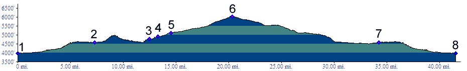
track turnoffs have been added. Dayrides with this point as highest summit PARTIALLY PAVED / UNPAVED Ut313 - Gemini Bridges Rd(sh) , Mineral
Bottom Rd(sh) : Willow Springs Road
> US191 south > up Gemini Bridges Rd >
Gemini Bridges Rd s(u) > down Ut313 a short
distance <> out and back on Mineral Bottom
Rd > to a turn around point a mile or two
inside Canyonlands NP, along the Green River
>> Mineral Bottom Rd(sh) > down Ut313
> back to starting point: 78.1miles with 4830ft
of climbing in 2:55hours (VDO MC1.0 m3:11.10.14). 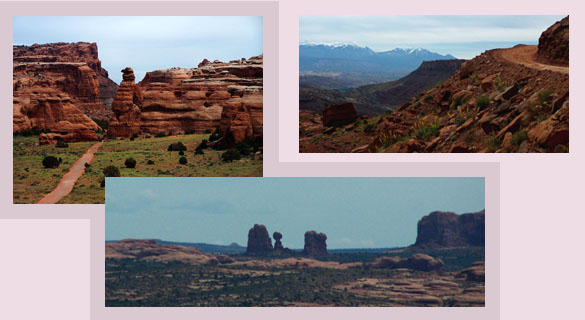 |
|
|
advertisement |
|
|
advertisement |