| |
| |
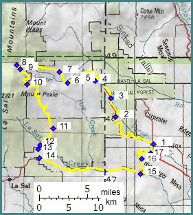
FR129 Geyser Pass s(u)
The La Sal Mountains serve
as orientation landmark for an entire region.
Geyser Pass is the most prominent pass in these
mountains, a gap in the middle of cone like peaks,
rounded on top, but falling off steeply. The pass
can be easily seen from an enormous distance,
ranging from points east in Colorado's Uncompaghre
Plateau, to points west in the "island in the sky
plateau" west of Moab. . The La Sal Mountains
gleam in the distance, hinting at another world
that is much higher and cooler than the plateaus
it is visible from. The reverse is not true. The
pass is tree covered and farther views are located
lower on the approaches. When climbing the pass on
a bicycle, another aspect of the topography
becomes obvious. These peaks sit on a big plateau.
The first big impression as well as the first big
effort is involved in climbing these sedimentary
dessert steps to the table on which the peaks sit.
Geyser Pass has three principal
approaches, that meet at the summit. The ones from
the east ( from Paradox ) and west ( from Moab )
make good approach routes for cycling. The
approach from the south ( Ut46 or La Sal )
contains sections near the top, that are a wide
dirt road with bad sandy washboard. It goes over
an altitude that is slightly higher than Geyser
Pass itself. It is more easily traversed in a
downward direction. But in order to come up with a
loop ride that can be cycled in a day the southern
approach becomes attractive.
Eastern - Southern ( Paradox
- Ut46) Approaches
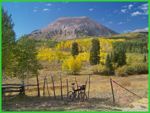
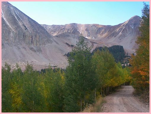
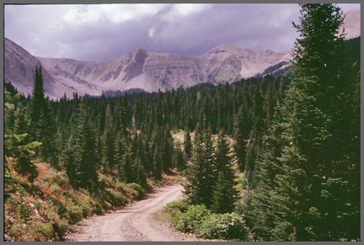
From East. The climb begins in the prototypical Colorado Plateau Valley: cliffs, straight as an arrow and as far as the eye can see, and barely a creek that could have carved all this in sight. The paved climb up FR371 on the west side of town must be one of the nicest paved climbs in the state of Colorado, if it wasn't for one thing: the surface turns to dirt just after reaching the edge of the plateau. The route winds through a dense forest, curving northwards to Buckeye Reservoir. Continuing towards Geyser Pass the route becomes noticeably less traveled. Glimpses of the range ahead through the dense forest are rare until the road enters Pine Flats. No trespassing signs at the entrance of this hunting reserve try to give the impression that this is not a public road, which it is. The route towards the pass continues along the first left fork after entering the reserve. The next large junction offers a quick way back to the starting point over Canopy Gap. Go straight for Geyser Pass. After passing a hunting camp and turning northwards again, comes the most tricky part of the route. A much less traveled rocky track heads steeply off the main dirt road, heading towards the peaks. This is not the road marked as Geyser Creek Road on National Forest maps, but a track to the south. Geyser Creek Road is a prominent forest road that turns towards the peaks a few miles later, ending at a locked gate to the hunting reserve. The steep rock track to the pass becomes much less steep and rocky, soon after the turnoff. It traverses extensive open aspen groves with much up and down. A tiny hut in the San Juan hut system is passed in conjunction with a lake, shortly before reaching the pass. The pass is at the junction of the three outlined approaches. As of Sept/05 there is no summit sign. It looked like it may have just been removed, maybe to be replaced. But the designation "Geyser Pass" is used in signs along all the upper approaches. On this approach however, there are no signs until past the San Juan hut (Sept/05). All three pictures on this page are taken on this
approach. The second shows the Paradox Valley
during the first climb. No3 taken in the vicinity
before Buckeye Reservoir. No2 shows the last
effort stretch before reaching the hut near the
summit.
From West. The route from the west begins
at the southern end of Spanish Valley, Moab area.
The well used dirt road climbs Bromley Ridge.
From South. Of the three approaches, this road has been modified the most to make it suitable for automobiles, which means a broad dusty washboard in places (Sept/05). It's described in a downward direction. The broad road traverses around Mount Mellenthin and Mount Peale, often at a point where the almost football shaped peaks rise the most steeply. The road has every kind of grade imaginable, steep downhills, then nearly level, a short uphill. Several junctions along the way have signs pointing to secondary destinations, along roads which are just as heavily used as the route back into the valley. Especially signs, stating that I was on the route to "Dark Canyon" made me wonder if I had missed a turnoff somewhere. Having a map ready here is more that just a thing that is nice to have. It turns out I was on the right route. The long extended roll down the pass finally happens on the more gentle aspen covered southern portion of the plateau. As of 2011 the route is a fast dirt road and not the wide washboard surface that I experienced during earlier years. In any coase hardtop is near. One more left turn through a ragged settlement of mobile homes and Ut46 is ready to carry the cyclist back to the start in smooth paved comfort. The profile includes the rest of Ut46 back to
Paradox. At the end waits a surprise, a 500 ft
climb over Nyswinger Mesa back to Paradox.
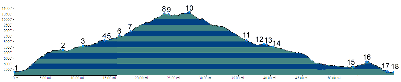
Dayride A loop ride starting in Paradox, going up the eastern approach and returning over the southern approach measured 71 miles with 8000 feet of climbing in 7:25 hours (m3:05.09.22). This included over 10 miles of getting lost and exploring the area around point 7. Another loop beginning at the "La Sal Loop Road"
turnoff on the western side, going over Geyser
Pass and then returning over La Sal Pass measured
66 miles (m1:91.09.01)
Extended Tours The San Juan Hut system is often used in an
extended tour over the pass. Usually two days are
used to traverse the summit over the eastern and
western approaches. The first day connects the
huts in Paradox and the one before the summit. The
second day goes over the summit down to Moab.
|
 Approaches