| |
|
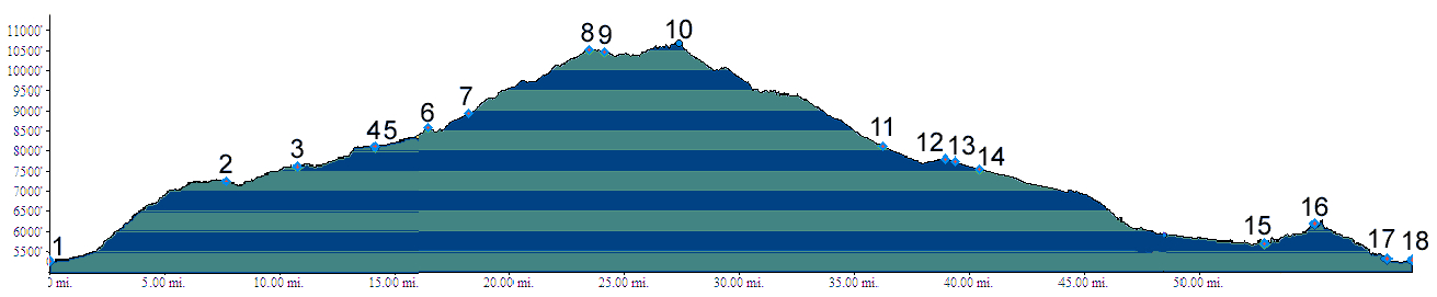
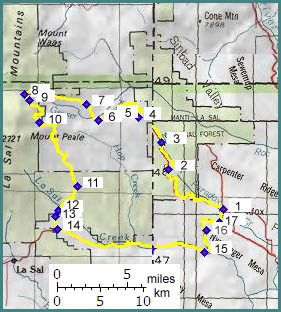
01.(5300ft,mile00) START-END EAST-NORTH: Paradox
02.(7260ft,mile07) junction with dirt road on left. Profile continues straight
03.(7630ft,mile11) Buckeye Reservoir
04.(8350ft,mle15) junction with dirt road on left. Profile continues straight
05.(8360ft,mile15) dirt road on left goes to Canopy Gap. Profile continues straight
06.(8580ft,mile17) stay right at fork
07.(8950ft,mile19) go left up much less traveled route. This turn off is easy to miss
08.(10538ft,mile25) Geyser Pass. Profile continues south towards La Sal. Straight goes to Moab.
09.(10470ft,mile25) stay straight (left fork)
10.(10700ft,mile28) TOP: point of highest altitude
11.(8110ft,mile36) dirt road on left goes to Canopy Gap. Profile continues right.
12.(7800ft,mile39) dirt road on right goes to La Sal Pass. Profile takes left fork.
13.(7740ft,mile39) profile takes short cut on left to Ut46
14.(7560ft,mile41) route joins Ut46, and continues left.
15.(5710ft,mile53) Ut46 leaves La Sal Creek and climbs over hogback towards Paradox Valley.
16.(6220ft,mile55) top of hogback
17.(5350ft,mile59) profile goes left to Paradox
18.(5300ft,mile60) START-END EAST-SOUTH: Paradox (same as point 1)