< Left Panel   Utah Summits and Passes   Areas   Tables   Maps   All Favorites  
Main Panel:   Main Page   Map+Profile   Utah Map  


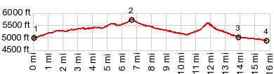
CR4170 Southam Canyon Rd s(u)

This summit point connects two points on the White River. I think it is the most scenic point, in this maze of gravel roads, originally constructed to service the mining and gas development in this area, that I have come across so far.

1.START-END NORTH:bridge across White River on UT45, south of Bonanza
2.TOP: 5750ft
3.jct with Asphalt Wash Rd, profile turns right
4.START-END SOUTH:road meets White River

Approaches

From North.
The first part is on pavement and climbs on Ut45 away from the White River Boat Launch. Before the wide cracked paved road ends at a securely locked gate to an oil shale reservation, Southam Canyon Road diverts to the left. This is not the turnoff to Baxter Pass, but the one after that. In many turns Southam Cny Rd follows one of the many intermediate shallow shelfs, in this series of cliffs. In the end a small climb opens the view on more cliffs to the west. White river is still far out of sight


From South. (described downwards). A short descend leads to another small climb that is not big enough to be considered a separate summit point. It's another pretty vantage point. The road ends at a T junction onto Asphalt Wash Road. The way north, on this fast, flat, very bikable road lends itself to multiple loop possibilities (which is what I did). But the way to the river and the bottom point goes right.

cLiCk on image , arrows , or thumbnails to advance slideshow


A Dayride with this point as intermediate location is on page: CR4190 Kings Wells Rd -1 s(u) (t20_2)


advertisement

advertisement